
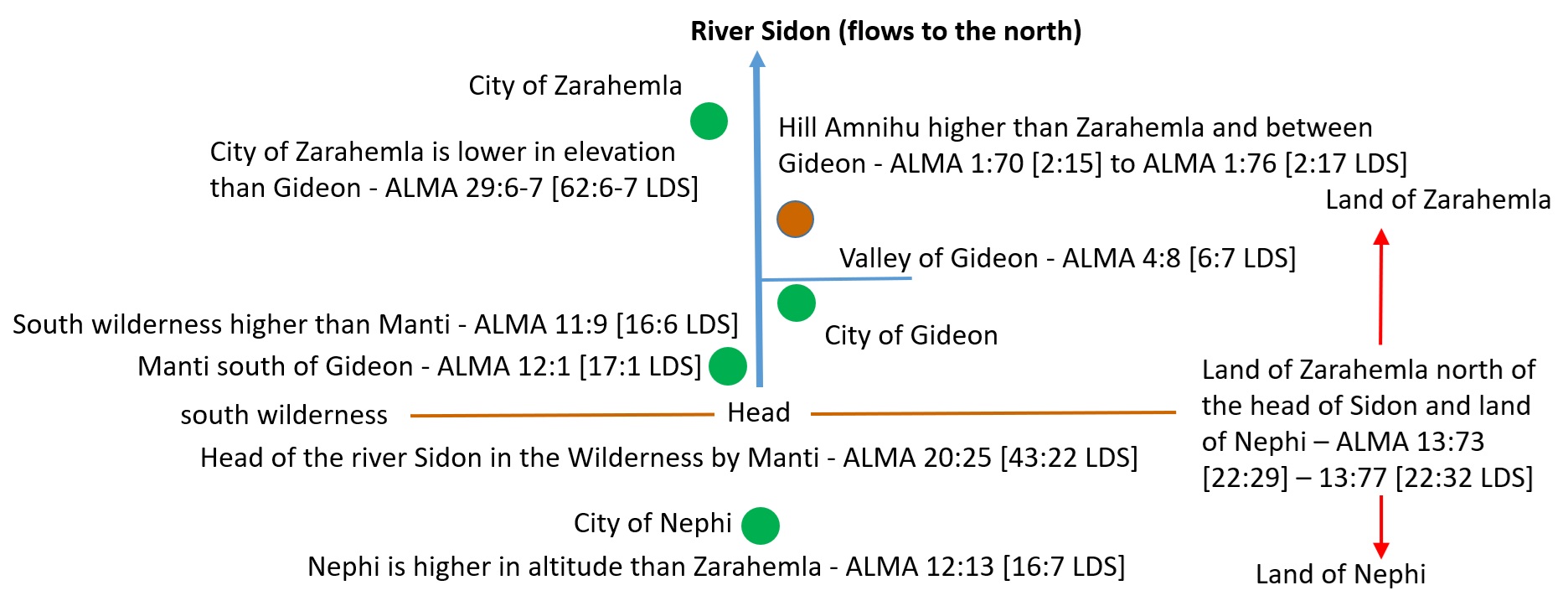
There is a north-flowing river described in the Book of Mormon. The Book of Mormon doesn't state directly that it is north-flowing. The individual descriptions of altitude indicate that the river flows from the south to the north.
ALMA 29:6 [62:6] And thus when Moroni had gathered together whatsoever men he could in all his march, he came to the land of Gideon; and uniting his forces with that of Pahoran, they became exceeding strong, even stronger than the men of Pachus, who was the king of those dissenters who had driven out the freemen out of the land of Zarahemla, and had taken possession of the land.
ALMA 29:7 [62:7] And it came to pass that Moroni and Pahoran went down with their armies into the land of Zarahemla and went forth against the city, and did meet the men of Pachus, insomuch that they did come to battle.
- Commentary: The phrase 'went down' in Hebrew is <yarad> [Strong's H3381] verb - to go down, descend, decline, march down, sink down. The term <yarad> in Hebrew literally refers to down in altitude. From this description, the land of Gideon is higher in altitude than the city of Zarahemla.
ALMA 1:70 [2:15] And it came to pass that the Amlicites came upon the hill of Amnihu, which was east of the river Sidon, which ran by the land of Zarahemla, and there they began to make war with the Nephites.
ALMA 1:71 [2:16] Now Alma, being the chief judge, and the governor of the people of Nephi, therefore he went up <`alah> with his people, yea, with his captains, and chief captains, yea, at the head of his armies, against the Amlicites to battle; and they began to slay the Amlicites upon the hill east of Sidon.
ALMA 1:76 [2:20] And it came to pass that when Alma could pursue the Amlicites no longer, he caused that his people should pitch their tents, in the valley of Gideon, the valley being called after that Gideon who was slain by the hand of Nehor with the sword; and in this valley the Nephites did pitch their tents for the night.
- Commentary: The phrase 'went up' in Hebrew is <`alah> [Strong's H5927] verb - to go up, ascend, climb. The term <`alah> in Hebrew literally refers to up in altitude. From this description, The hill Amnihu is between Zarahemla and the valley of Gideon. And, the hill Amnihu is higher up in altitude than the city of Zarahemla.
ALMA 12:1 [17:1] And now it came to pass that as Alma was journeying from the land of Gideon, southward, away to the land of Manti, behold, to his astonishment, he met the sons of Mosiah, journeying towards the land of Zarahemla.
- Commentary: The land of Manti is south of the land of Gideon. Zarahemla is in the opposite direction (north) of Manti and Gideon.
ALMA 11:9 [16:6] And Alma returned and said unto them, Behold, the Lamanites will cross the river Sidon, in the south wilderness, away up <`alah> beyond the borders of the land of Manti.
ALMA 11:10 [16:6] And behold there shall ye meet them, on the east of the river Sidon, and there the Lord will deliver unto thee thy brethren who have been taken captive by the Lamanites,
ALMA 11:11 [16:7] And it came to pass that Zoram and his sons crossed over the river Sidon with their armies, and marched away beyond the borders of Manti, into the south wilderness, which was on the east side of the river Sidon.
- Commentary: The south wilderness is higher in elevation (up) from Manti. The way through the south wilderness is on the east side of the river Sidon.
ALMA 20:25 [43:22] Behold, now it came to pass, that they durst not come against the Nephites in the borders of Jershon; therefore they departed out of the land of Antionum, into the wilderness, and took their journey round about in the wilderness, away by the head <ro'sh> [Strong's H7218] of the river Sidon, that they might come into the land of Manti, and take possession of the land; for they did not suppose that the armies of Moroni would know whither they had gone.
- Commentary: The south wilderness is higher in elevation (up) from Manti. The head (beginning) of the river Sidon is in the wilderness around Manti. Water flows downhill (to a lower elevation) from its head.
- <ro'sh> [Strong's H7218] head, top, summit, upper part, chief, total, sum, height, front, beginning (it does not mean 'confluence' - see Head of the River Sidon)
- Book of Mormon uses the Hebrew definition: 1 Nephi 2:55 [8:14] And I looked to behold from whence it came; and I saw the head <ro'sh> thereof a little way off;
ALMA 12:11 [17:7] Nevertheless they departed out of the land of Zarahemla, and took their swords, and their spears, and their bows, and their arrows, and their slings;
ALMA 12:13 [17:8] And thus they departed into the wilderness, with their numbers which they had selected, to go up to the land of Nephi, to preach the word of God unto the Lamanites.
- Commentary: The land of Nephi is beyond Manti, through the (south) wilderness. The land of Nephi is higher in elevation than the land of Zarahemla.
ALMA 13:73 [22:29] Nevertheless the Nephites had taken possession of all the northern parts of the land, bordering on the wilderness, at the head of the river Sidon, from the east to the west, round about on the wilderness side; on the north, even until they came to the land which they called Bountiful.
ALMA 13:77 [22:32] And thus the land of Nephi, and the land of Zarahemla, were nearly surrounded by water; there being a small neck of land between the land northward, and the land southward.
- Commentary: The land of Zarahemla is in the area north of the head of the river Sidon. There is a "wilderness" side near the head of the river Sidon (There is a "wilderness" side near the head of the river Sidon). The land of Nephi is outside (south) of the land of Zarahemla.
Plotting all of the information in these verses on an internal map gives us a picture of the river Sidon and the direction that it flows.
The Direction of Flow for the River Sidon
(Tap to Expand)
Isthmus of Tehuantepec (Mexico) Model Assessment:
For the Isthmus of Tehuantepec location for the narrow neck, the only river that meets the criteria is the Usumacinta River.
- The Usumacinta River is located south of the Isthmus of Tehuantepec
- There is a 400-foot high hill on the east of the river north of a river that joins the Usumacinta River from the east (Rio Pasion)
- The Usumacinta River is located south of the Isthmus of Tehuantepec
- The Head of the Usumacinta River is in the wilderness to the south
- Where the Usumacinta River enters the south wilderness, there are a west and east valleys and the east valley is the route through the wilderness
River Sidon (Isthmus of Tehuantepec)
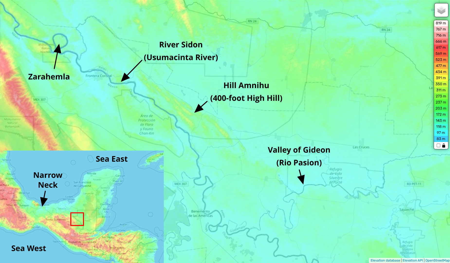
(Tap to Expand)
West and East Valleys (Isthmus of Tehuantepec)
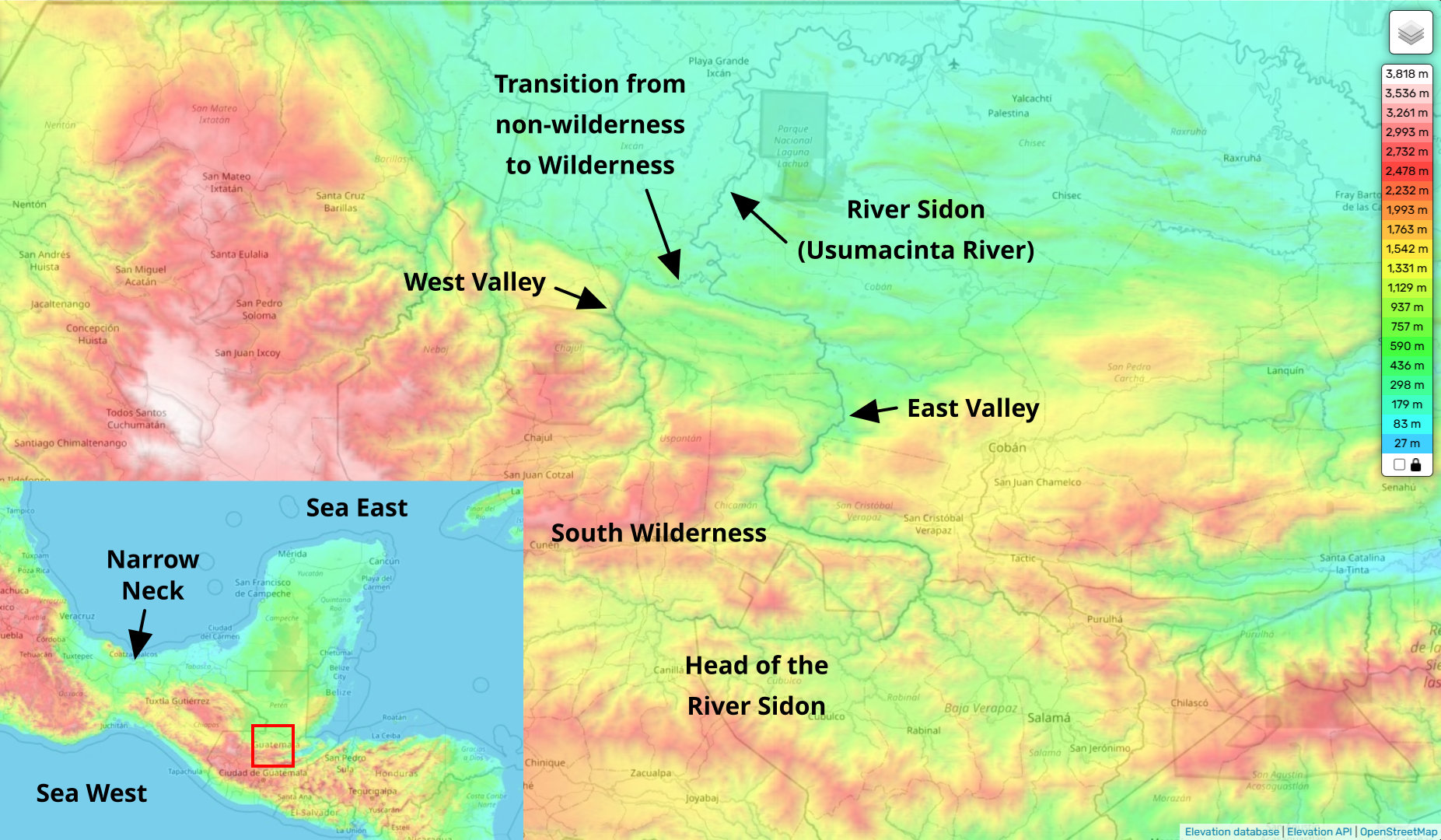
(Tap to Expand)
Heartland Model Assessment:
The Heartland Model claims that the Mississippi River is the River Sidon [Source]. The Heartland Model also identifies the Ohio (and Allegheny) and Missouri Rivers for the 'narrow strip of wilderness.' [Source]
- 'NARROW STRIP OF WILDERNESS- The Allegheny, Ohio, Mississippi, and Missouri Rivers act as a west to east fence, across the United States. This is the main border between the Nephites and Lamanites from about Independence MO to Hill Cumorah. The gate of the fence is the Small Neck of Land which is why the Nephites and Lamanites were "nearly" surrounded by water. Alma 22:27. Rivers are well known as a type of wilderness where there are marshes, weeds, and unusable space along both banks of rivers, thus creating a wilderness area where people don't live, especially if the river bed is low or dry.' [Source]
- 'I propose that the narrow strip of wilderness is a major river-or system of rivers-that serves as an effective border...The "narrow strip" element suggests a feature that is visible and obvious to people on the ground; i.e., narrow enough that observers can see how wide it is, and long and thin enough that it is not mistakable. It is a definite border, not a vague region. Second, the definitions of the terms offer similar connotations. Narrow suggests a vale, valley, or river bed. Strip suggests something that is long and thin-like a river... In the past, however-in Book of Mormon times-the Ohio River often dried up in late summer. This left the riverbed as an expanse of silt and mud. In that state, it could not be called a river. But it could still be a border, and it could still be called a "narrow strip of wilderness." ' [Source]
Mississippi as the River Sidon (Heartland Model)
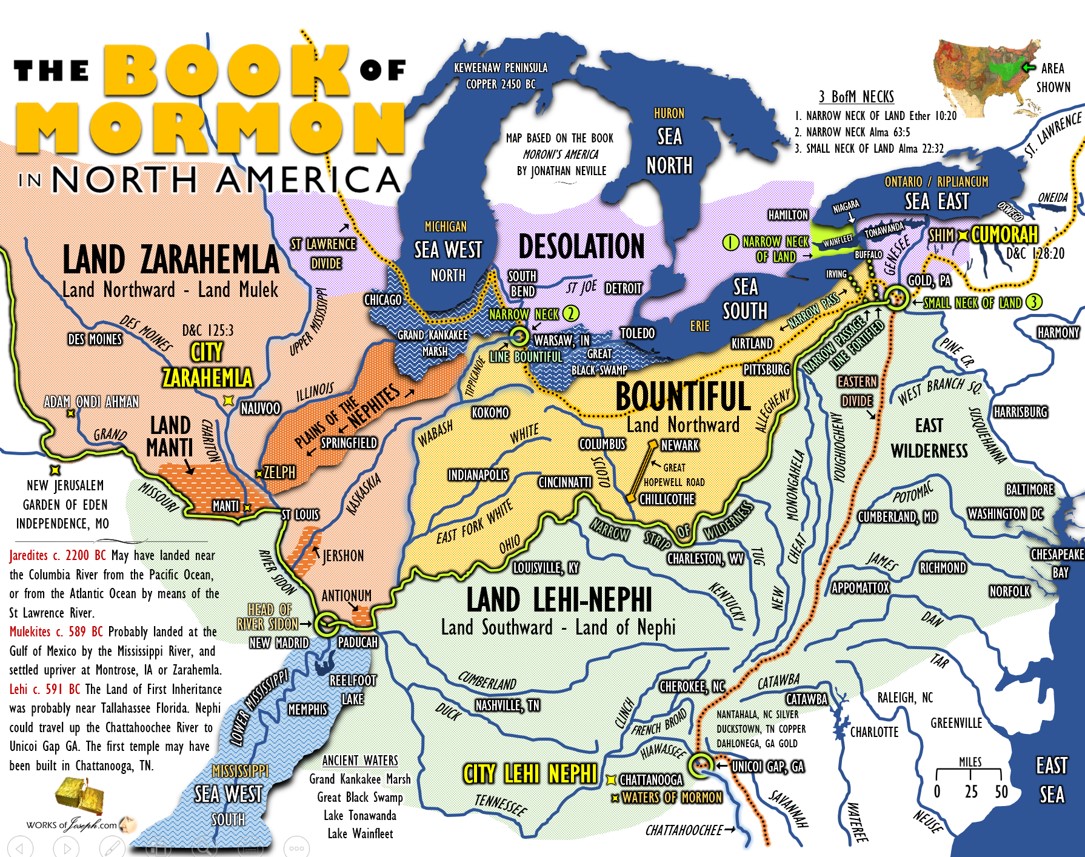
(Tap to Expand - Source)
- The Mississippi River flows southward, not northward (as described by the altitude descriptions in the verses from the Book of Mormon listed above).
- The Heartland Model does not specify a hill on the east of the Mississippi River (hill Amnihu).
- The head of the Mississippi River is not a confluence of rivers (see the explanation of the two logical fallacies used to define 'head' by the Heartland Model at the Head of the river Sidon)
Narrow Strip of Wilderness - South Wilderness (Heartland Model)

(Tap to Expand - Source)
Did the Sidon River flow north? [Source: bookofmormonevidence.org]
- Q: Is it correct that the [LDS] Book of Mormon index indicates the Sidon River flows north to a sea?
- A: No. In the LDS index in the Book of Mormon "used to" state that the Sidon River is the "most prominent river in Nephite territory, runs north to sea". That has changed.
- Significant Change Made in New Book of Mormon Index Regarding River Sidon (March 2013)
- [LDS] Church leadership recently changed (March 2013) the description of the River Sidon in the Book of Mormon Index to reflect what is scripturally demonstrable. It now states simply, "Sidon, River - most prominent river in Nephite territory" removing the speculative assumption that it "runs north to a sea" That the river empties into a sea is not in question (see Alma [LDS] 3:3, 44:22 ), which indicates that the cause of the removal of the claimed direction of flow of the river from the index is the result of having no scripturally explicit text so indicating. Nowhere does the text of the Book of Mormon definitively state the direction of flow of the Sidon River, therefore it was simply deduced from alternative sources of information. [LDS] Church leadership has now rectified this situation. There is no textual demand for the River Sidon to have been a north flowing river as now acknowledged officially by the Church.
Commentary: An Index of the Book of Mormon is not a scholarly analysis of the Book of Mormon. It is an index for locating topics, chapters, and verses. In the verses and analysis above, the Book of Mormon describes clearly that the river Sidon flows through terrain that rises in altitude towards the south and the river has its headwaters in the south. This is scripturally explicit text that the river flows towards the north.
Assessment of the Heartland Model interpretation of 'narrow wilderness'
Nowhere in the Heartland Model definition or premises for the narrow strip of wilderness is there any consideration for the descriptions of wildernesses in the Book of Mormon or the Hebrew meaning for the word 'wilderness.'
wilderness <midbar> [Strong's H4057] - wilderness, pasture, uninhabited land. Gesenius' Hebrew-Chaldee Lexicon - an uninhabited plain country fit for feeding flocks; a sterile, sandy country.
The Hebrew word <midbar> is used very clearly in the Old Testament. The word 'wilderness' in the Old Testament is translated from <midbar> 249 times while 14 times other Hebrew words meaning dry deserts and sterile places are translated into 'wilderness.' So, <midbar> is well established as the root for 'wilderness' where animals can feed but too dry for human habitation, and <midbar> is used 249 times in the Book of Mormon to describe 'wilderness' with 3 instances of 'wilderness' using a different Hebrew word. The descriptions of wildernesses in the Book of Mormon describe them as rising in altitude, not valleys. The descriptions in the Book of Mormon also contrast 'rivers' and 'wildernesses' indicating that 'wildernesses' are not rivers.
NUMBERS 21:5 And the people spake against God , and against Moses, Wherefore have ye brought <`alah> us up out of Egypt to die in the wilderness <midbar>? for there is no bread, neither is there any water; and our soul loatheth this light bread.
NUMBERS 21:8 And the Lord said unto Moses, Make thee a fiery serpent, and set it upon a pole: and it shall come to pass, that every one that is bitten, when he looketh upon it, shall live.
NUMBERS 21:11 And they journeyed from Oboth, and pitched at Ijeabarim, in the wilderness <midbar> which is before Moab, toward the sunrising.
- Commentary: Here in the Old Testament the wilderness was higher up (Hebrew <`alah>) than Egypt. The use of <midbar> here confirms the lack of water.
ALMA 16:191 [33:18] Behold, he was spoken of by Moses; yea, and behold, a type was raised up in the wilderness <midbar>, that whosoever would look upon it might live. And many did look and live.
- Commentary: The word 'wilderness' here is the same <midbar> as in Numbers 21:5-11.
ENOS 1:32 [1:20] Feeding upon beasts of prey, dwelling in tents, and wandering about <ta`ah> [Strong's H8582] in the wilderness <midbar>,...
- Commentary: <ta`ah> means 'to wander about' indicating that the area is firm ground for walking and a large enough area to move about.
OMNI 1:48 [1:27] And now, I would speak somewhat concerning a certain number who went up <`alah> into the wilderness <midbar>, to return to the land of Nephi:
ALMA 11:9 [16:6] And Alma returned and said unto them, Behold, the Lamanites will cross the river Sidon, in the south wilderness <midbar>, away up <`alah> beyond the borders of the land of Manti.
ALMA 12:13 [17:8] And thus they departed into the wilderness <midbar>, with their numbers which they had selected, to go up <`alah> to the land of Nephi, to preach the word of God unto the Lamanites.
- Commentary: These verses speak directly to the narrow wilderness (south wilderness) as being rising terrain that goes 'up' (not a valley).
ALMA 13:68 [22:27] And it came to pass that the king sent a proclamation throughout all the land, amongst all his people who were in all his land, who were in all the regions round about, which was bordering even to the sea, on the east, and on the west, and which was divided from the land of Zarahemla by a narrow strip of wilderness <midbar>,
ALMA 13:69 [22:27] Which ran from the sea east, even to the sea west, and round about on the borders of the sea-shore, and the borders of the wilderness <midbar> which was on the north, by the land of Zarahemla, through the borders of Manti, by the head of the river Sidon, running from the east towards the west; and thus were the Lamanites and the Nephites divided.
- Commentary: This is the description of the 'narrow strip' of wilderness <midbar>. It ran from the sea east to the sea west - there is only one river in the world that flows into two oceans (Atlantic Creek and Pacific Creek in Two Ocean Pass, Wyoming). Alma 13:69 also states that the narrow strip of wilderness ran by the head of the river Sidon - using the Heartland Model definition - the 'wilderness' river that went from the sea East to the sea West also originated a river (river Sidon) that flowed to the north (a three-way river system) - which does not exist anywhere in the world. Using the Hebrew definition for 'wilderness,' the narrow strip of wilderness is rising terrain (i.e. hills / plateaus, etc.) that runs from the sea East to the sea West - a place of rising east/west terrain is a natural location for the 'head' of a north-flowing river.
ISAIAH 50:2 Wherefore, when I came, was there no man? when I called, was there none to answer? Is my hand shortened at all, that it cannot redeem? or have I no power to deliver? behold, at my rebuke I dry up the sea, I make the rivers <nhar> a wilderness <midbar>: their fish stinketh, because there is no water, and dieth for thirst.
2 NEPHI 5:53 [7:2] Behold, at my rebuke, I dry up the sea, I make their rivers <nhar> a wilderness <midbar> and their fish to stink, because the waters are dried up; and they die because of thirst.
- Commentary: These verses provide a direct contrast between a river <nhar> and a wilderness <midbar> - they do not share the same definition in that God turns one into the other.
SUMMARY: The Mississippi River does not match the descriptions for the northward direction of flow for the river Sidon in the Book of Mormon. The Ohio and Missouri Rivers do not match the descriptions of wildernesses (rising terrain) in the Book of Mormon. The Heartland Model ignores the Hebrew of the Book of Mormon and makes its own definitions for words.
Candidate River Sidon locations:
These locations meet the basic requirements for being the River Sidon.
- North-flowing river located south of the narrow neck
- Hill on the east of the river north of a valley / river that joins the north-flowing river from the east
- The head of the river in a narrow (south) wilderness that extends from the sea East to the sea West
- Where the river enters the narrow (south) wilderness, there is a west tributary that goes into a west valley in the wilderness and there is an east tributary that goes into an east valley and this east valley leads through the narrow wilderness (allows travel through the wilderness)
Denmark
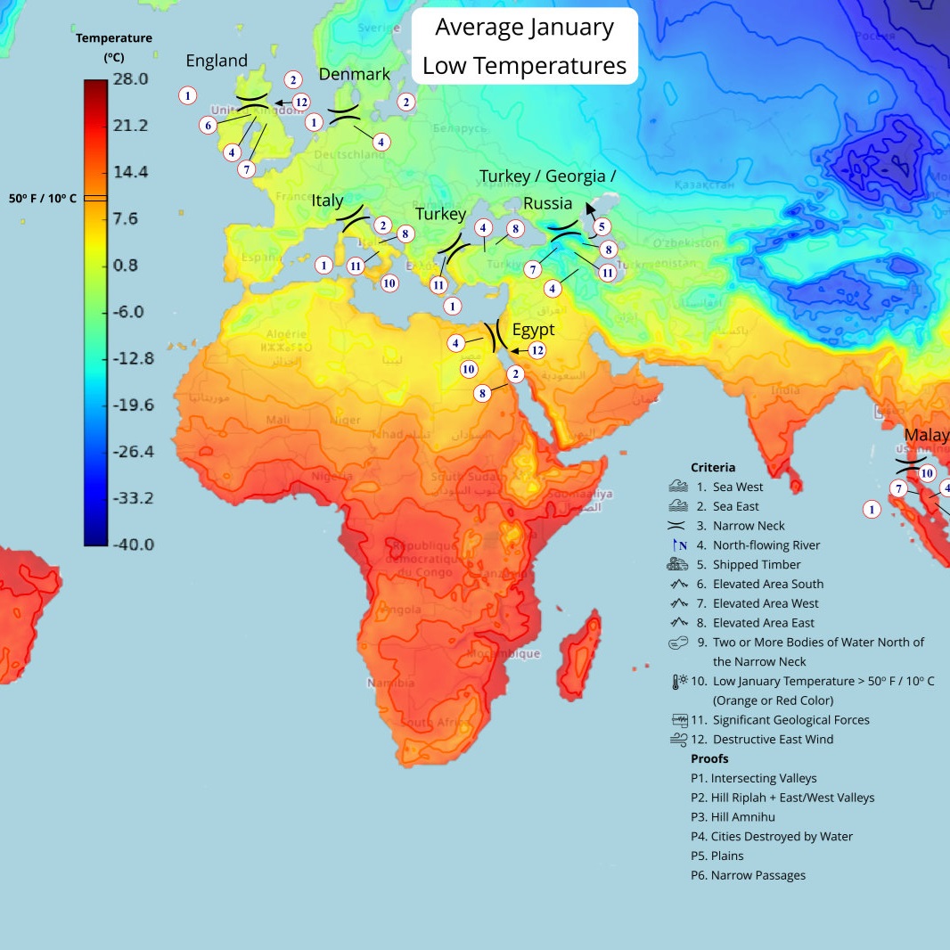
(Tap to Expand)
Click here for more information on the Denmark location.
Egypt
(Tap to Expand)
Click here for more information on the Egypt location.
England
(Tap to Expand)
Click here for more information on the England location.
Florida
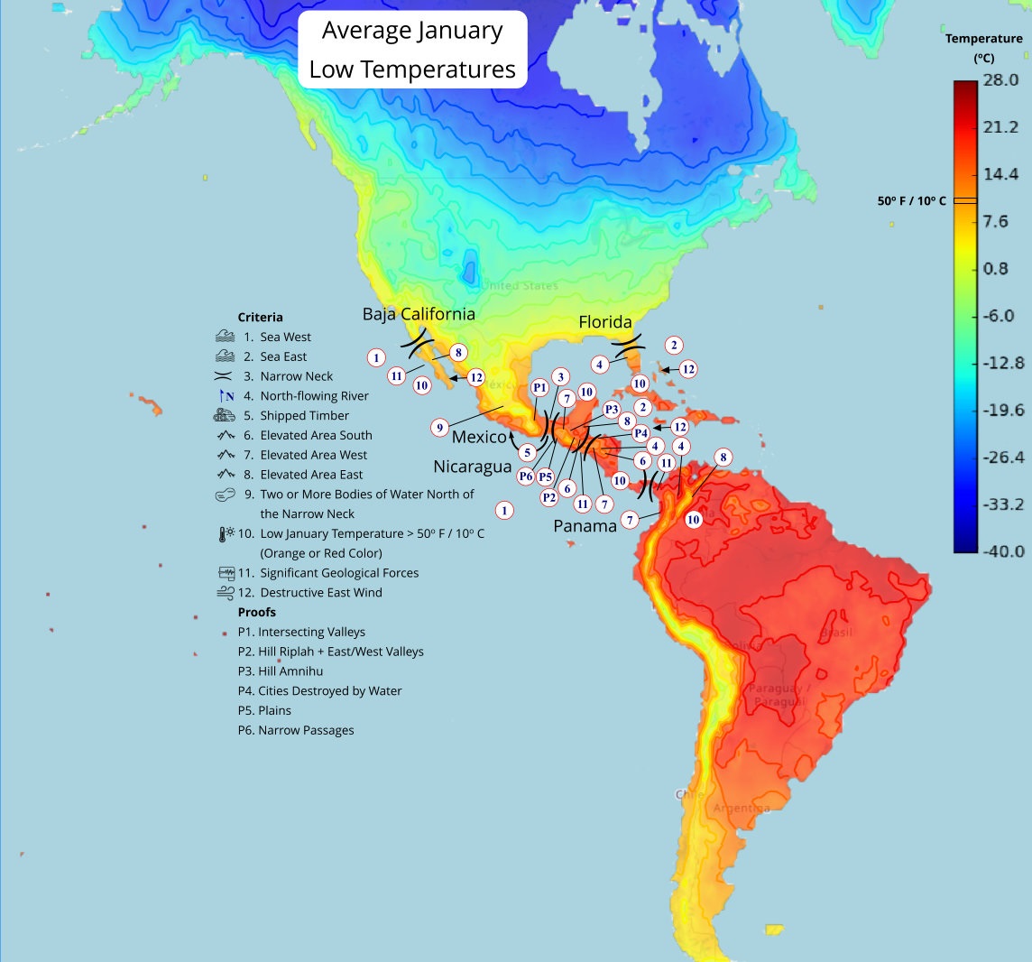
(Tap to Expand)
Click here for more information on the Florida location.
Korea
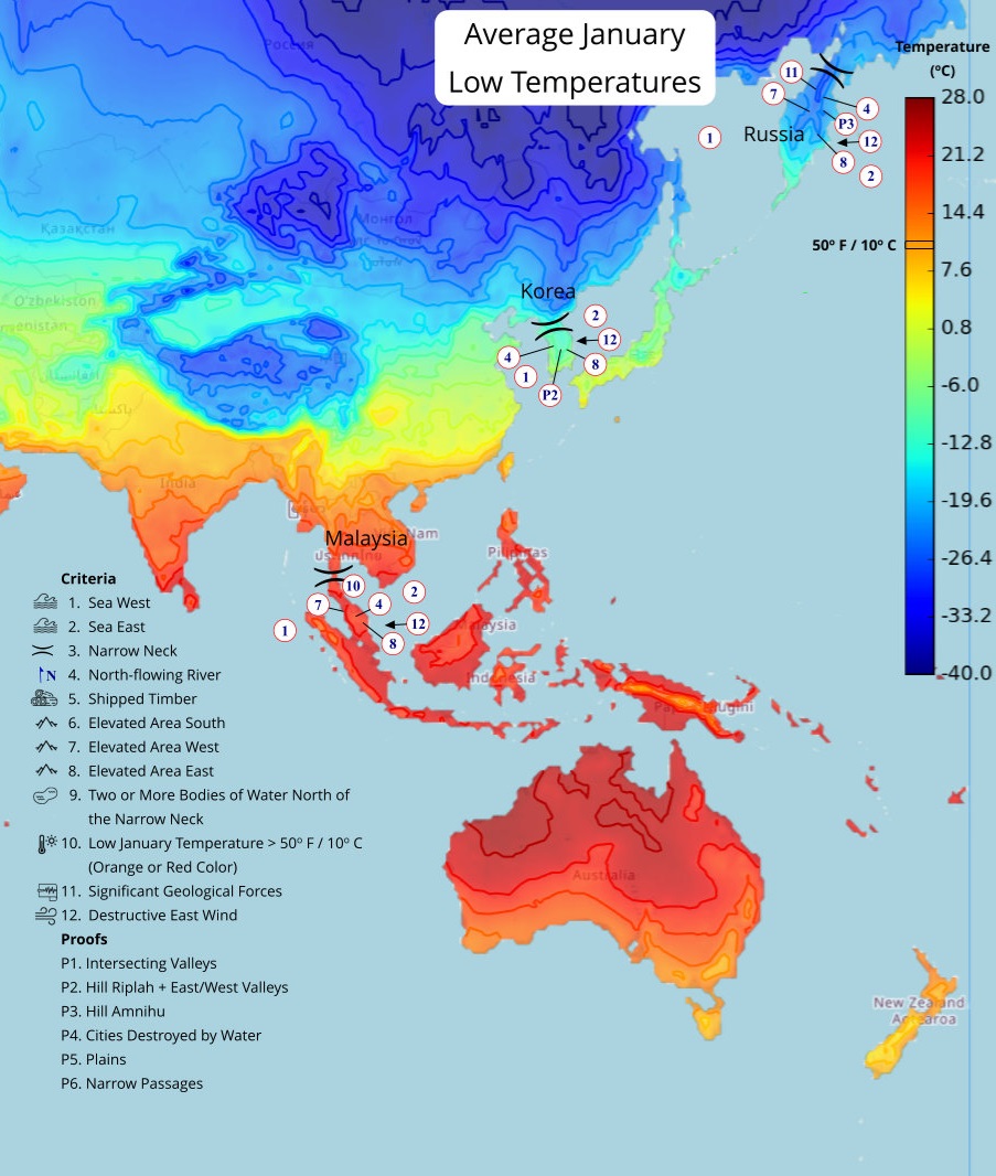
(Tap to Expand)
Click here for more information on the Korea location.
Mexico
(Tap to Expand)
Click here for more information on the Mexico location.
Nicaragua
(Tap to Expand)
Click here for more information on the Nicaragua location.
Panama
(Tap to Expand)
Click here for more information on the Panama location.
Russia
(Tap to Expand)
Click here for more information on the Russia location.
Turkey
(Tap to Expand)
Click here for more information on the Turkey location.
Turkey/Georgia/Russia
(Tap to Expand)
Click here for more information on the Turkey/Georgia/Russia location.
×
![]()