What constitutes a 'High Civilization'?
High Civilization is a society that has advanced in its culture, science, industry, and government for that time period. Below is a list of criteria that need to be met for the Book of Mormon Lands as postulated by the bookofmormoncentral.org website and responded to by the Heartland Model. [source: Rian Nelson, BOMC says the BOOK OF MORMON took place in MESOAMERICA? You Decide!, bookofmormonevidence.org, 2021]
bookofmormoncentral.org Criteria:
- A Narrow Neck of land and 4 seas (east, west, north, and south)
- Heartland Model Response: Niagara Peninsula, Ontario, Erie, Michigan, Huron.
- My Response: The bookofmormoncentral.org (now scripturecentral.org) fails to understand Hebrew metaphors - the only two actual seas are the sea West and the sea East - see 'Sea North and Sea South - Reality or Metaphor?'
- A major river running south to north from a narrow strip of wilderness.
- Heartland Model Response: Why south? The Index to the Triple Combination doesn't have this requirement.
- My Response: The Heartland Model must try to ignore the Book of Mormon verses that specifically describe the river Sidon flowing northward in order to justify Zarahemla being next to the Mississippi River that flows southward. The Index to the Triple Combination is NOT the Book of Mormon - it is an index and not a scholarly analysis of the Book of Mormon. The verses within the Book of Mormon are very clear that the river Sidon runs from the south to the north [see North Flowing River].
- A high civilization with cities, kings, artisans, military, and priests.
- Heartland Model Response: There are over 1,000,000 mounds and settlements in North America.
- My Response: There is no correlation between mounds in the Eastern United States and a 'high civilization' that would include cities, kings, artisans, military, or priests. Archaeologists have determined that very few of the mounds had major settlements in their proximity. They have determined that most settlements were small, agriculture-based, and located some distance away from the mounds. "Population appears to have grown throughout the Hopewell period, although even at the highest levels density was only on the order of one-half person per square mile." [source: TRADITION SUMMARY: HOPEWELL, ehrafarchaeology.yale.edu, Peter Peregrine and Sarah Berry, 2004]. See the entries below for population density in the United States and the Mayan areas of Guatemala for population density comparisons.
- An agricultural base large enough to support several millions of people.
- Heartland Model Response: Are you kidding. Is there anything larger than the Mississippi agricultural base?
- My Response: The Mississippi River system is capable of agriculture to support millions of people. The issue is that there was no population in the millions along the Mississippi River during the times of the Book of Mormon. Cahokia (1100 AD - much later than the Book of Mormon) only had an estimated population of 15,000 to 20,000.
- A highly literate (written language) society with scribes as important officers.
- Heartland Model Response: Yes the Nephites would have scribes and records that's why they buried them to protect them from Lamanites.
- My response: North American Indians did not have writing until the 1700's. No writing - no scribes.
- Functional calendar and dating systems.
- Heartland Model Response: Nephites had the moon and stars. Mayan's had the sun and stars. He Hebrews used the moon as a calendar just like the North American Natives. "Coriantumr was discovered by the people of Zarahemla; and he dwelt with them for the space of nine moons." Omni 1:21.
- My Response: The Maya also had a moon calendar system.
- A merchant class using weights and measures.
- Heartland Model Response: Native Americans used Wampum as legal tender.
- My Response: Wampum wasn't used for legal tender until Europeans arrived in the 1600's. To be fair, Mesoamerica does not have any archaeological evidence for monetary systems and weights during the Book of Mormon times either. Could this be a cultural feature that was lost with the destruction of the Nephites?
- Engineers to build houses, temples, towers, and highways using cement.
- Heartland Model Response: Page 207, 303 Annotated Book of Mormon.
- My Response: There is no specific reference to what on these specified pages is being used for a response. For example, Page 207 of the current edition of the Annotated Book of Mormon makes no reference to houses, temples, towers, highways, or cement. The information below describes what existed in the Eastern United States and Mesoamerica regarding temples, towers, highways, and cement in use between 600 B.C and 400 A.D.
- A warrior society involved in large battles using trained soldiers and sophisticated fortifications.
- Heartland Model Response: There are breastplates, arrowheads, pottery, proof of fires, roads, and buildings of earth and wood all over North America. Alma 49:11-12.
- My Response: I'm not sure this is a valid criteria. All societies had warfare and fortifications to some extent. The Book of Mormon describes armies, but does not describe them as standing armies or the amount of training they received to be warfighters.
- Legends of a white, bearded God.
- Heartland Model Response: Native Americans have Legends of the Great Spirit. (One god).
- My Response: Most of the tribes in North America have a concept of a single God of Creation. Without a written history, it's very difficult to trace the origins of any creation stories of the tribes in the United States region. The Maya had a concept of a God of Creation.
Heartland Model Assessment:
Concerning Kings:
 In North America, there are known instances of what are called "Paramount Chiefs." Powhatan was the paramount chief of Tsenacomoco, or tidewater Virginia, in the late 1500s and early 1600s. During his lifetime, he was responsible for uniting dozens of tribes into a single, powerful alliance. He was the highest authority in the region when English colonists arrived and built Jamestown fort in 1607.
Concerning Population Density:
 In North America, American Indians that lived in the area of the contiguous United States before Columbus have been estimated as a range from 3.8 million to 7 million people to a high of 18 million. The density of people in the 3.1 million square miles works out to be 1.2 people per square mile to 2.2 people per square mile to as high as 5.8 people per square mile. These densities are comparable to nomadic tribes and small agricultural settlements.
The list of large population centers in North America only lists cities in Mexico and Guatemala from 1500 BC to 200 AD. A large population center in the United States region does not appear on the list until Cahokia around 650 AD (after the Book of Mormon period) [source: List of North American settlements by year of foundation, Wikipedia]
Concerning a Written Language and Scribes:
 In North America, Heartland Indian tribes did not have a written language until the 1700's. Before the 1700's, the Objibwe used a few glyphs but not as writing. So, with no written language, there would be no scribes.
Concerning Lunar Calendars:
 In North America, many tribes kept track of time by observing the seasons and lunar months, although there was much variability. For some tribes, the year contained 4 seasons and started at a certain season, such as spring or fall. Others counted 5 seasons to a year. Some tribes defined a year as 12 Moons, while others assigned it 13. Certain tribes that used the lunar calendar added an extra Moon every few years, to keep it in sync with the seasons. [source: easterntrail.org]
Concerning Merchants using Weights and Measures:
 In North America, scales and weight were not known on the western continent previous to the discovery. There is no record of standards of dry or liquid measure, but it is probable that vessels of uniform size may have been used as such. [source: faculty.marianopolis.edu]
But Indigenous people didn't view wampum as money. Because the process of cutting the brittle shells into small cubes, drilling holes into them and then filing them into cylinders--all without breaking them--required great skill and delicacy, wampum was indeed a highly prized commodity. Still, the idea of using it as a kind of hard currency did not emerge until European contact in the 17th century. (The Massachusetts Bay Colony, for one, officially recognized it as currency in October 1650.) Dutch and English colonists, seeing its desirability, found a way to quantify wampum's value as a way to trade for furs and other goods with Indigenous people. To facilitate that trade, they also started manufacturing their own wampum, first at the cottage-industry scale and later in larger wampum "factories." [source: What Is Wampum--and How Was It Used? history.com, Nov 18, 2024]
Concerning Engineers to build houses of cement, temples, towers, and highways:
 In North America, the Indians used cements of animal, vegetal, and mineral origin, and sometimes combined two of these or added mineral substances for colouring. [source: faculty.marianopolis.edu]
According to an article in sciencedaily.com, the early indigenous people did not lead a simple life and were skilled workmen and engineers. They had the ability to construct earthen structures which were big in size in a matter of months, or probably weeks.
Concerning Artisans with Metal:
 In North America, the earliest examples of metalwork in the New World come from the "Old Copper" culture that flourished in the upper Great Lakes region of North America beginning about 4000 bc and continuing over the course of the next 2,000 years. [source: britannica.com
Metal / Copper Artisanry (Heartland)
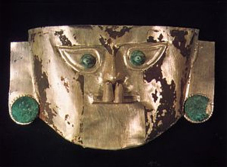
(Tap to Expand)
Concerning Artisans with Stonework:
 In North America, Native American ceremonial stone structures are found throughout the continental U.S. and portions of Canada. Northeastern U.S. and southeastern Canada have some of the highest concentrations of these structures. The structures include stone chambers, cairns, standing stones, enclosures, ceremonial walls, pedestal boulders (dolmens), balanced rocks, and niches. The sites are known as "Ceremonial Stone Landscapes" (CSL).
Stone Artisanry (Heartland)
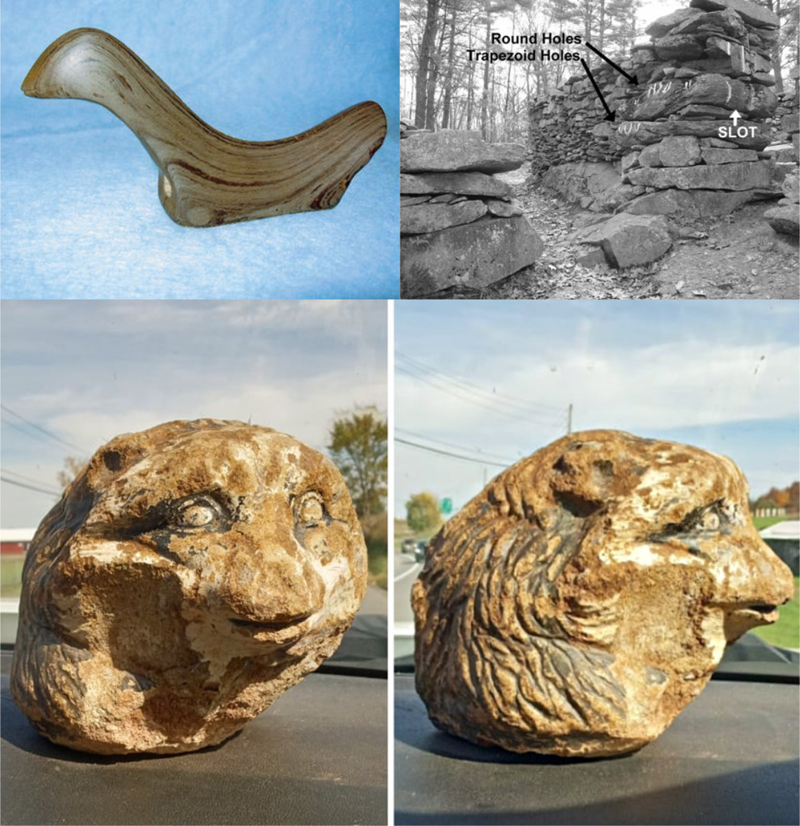
(Tap to Expand)
Concerning Fortifications:
 In North America, North American Indian fortifications varied depending on the region and tribe, but often included structures like earthwork mounds, palisades made of logs (as high as 10 meters), and strategically placed defensive positions utilizing natural features like rivers and cliffs,
Isthmus of Tehuantepec (Mexico) Model Assessment:
Concerning Kings:
 In Mesoamerica, Maya monarchs, also known as Maya kings and queens, were the centers of power for the Maya civilization. The density of people in the 120,000 square miles of the Mayan lands is 17 to 83 people per square mile, up to 14 times the density of Native Americans in the United States.
Concerning Population Density:
 In Guatemala, southeastern Mexico, and northern Honduras, the Maya population may have reached 2 million or as many as 10 million. Many cities contained 50,000 to 120,000 people.
Concerning a Written Language and Scribes:
 In Mesoamerica, the Olmec and Maya had writing. Fifteen distinct writing systems have been identified in pre-Columbian Mesoamerica. Pictured below is a scribe from the Codex Telleriano-Remensis and Mixtec scribe from the Codex Vindobonensis.
Scribes (Mesoamerica)
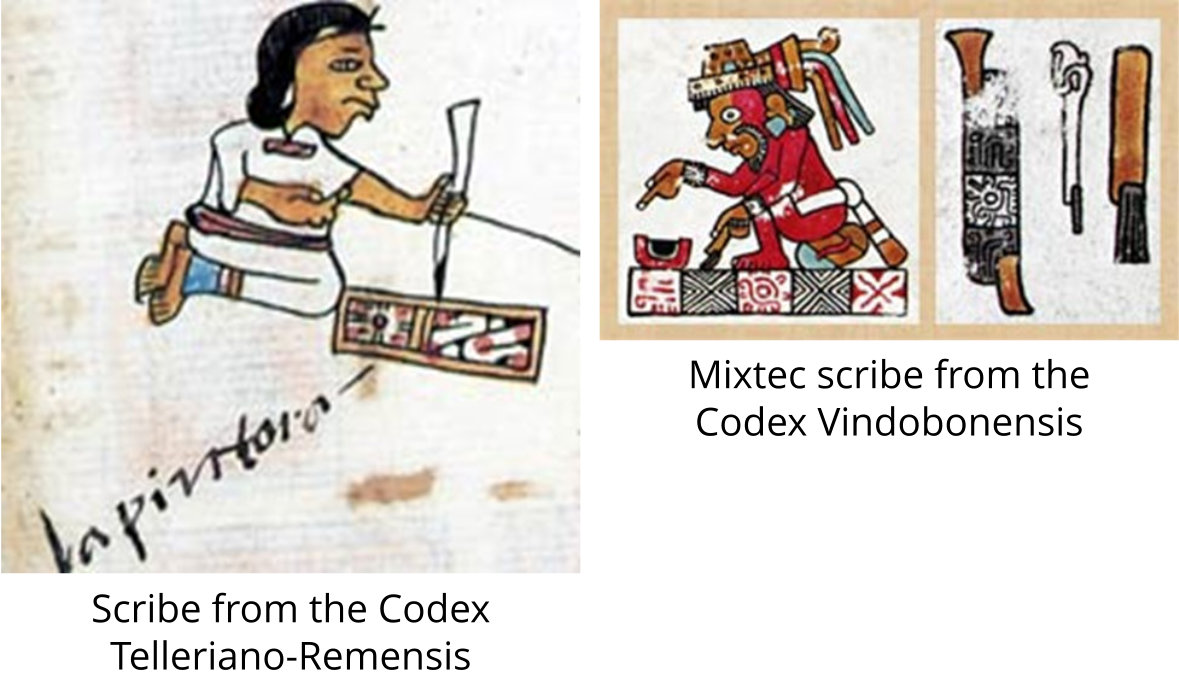
(Tap to Expand)
Concerning Lunar Calendars:
 In Mesoamerica, the Lunar Series was the first Maya original contribution to the calendar ... There is good evidence to say that the Maya were able to calculate the actual length of an average lunation very accurately. The Lunar Series chooses 29 or 30 days, following the Maya penchant for expressing only whole numbers, ... [source: mayan-calendar.com]
Concerning Merchants using Weights and Measures:
 In Mesoamerica, although Aztecs appear to have never used scales, they used numbers of easily countable items and volumes of specific commodities to facilitate trade. For example, they used a quauhchiquihuitl -- a wooden box subdivided into divisions as small as one-twelfth -- for the purpose of measuring corn and other dry goods. They also produced leather bags, cups and jars of graded sizes for measuring dry and liquid goods, such as cocoa beans, resins, water, honey and oils. The Maya also used volume measures, such as the "armload" and "fistful".
 Although the Incas did develop and employ scales, there is no evidence that resulting measurements were relative to a standard; rather, goods were likely weighed in relation to other goods. [source: nist.gov]
Inca Scales (Peru)
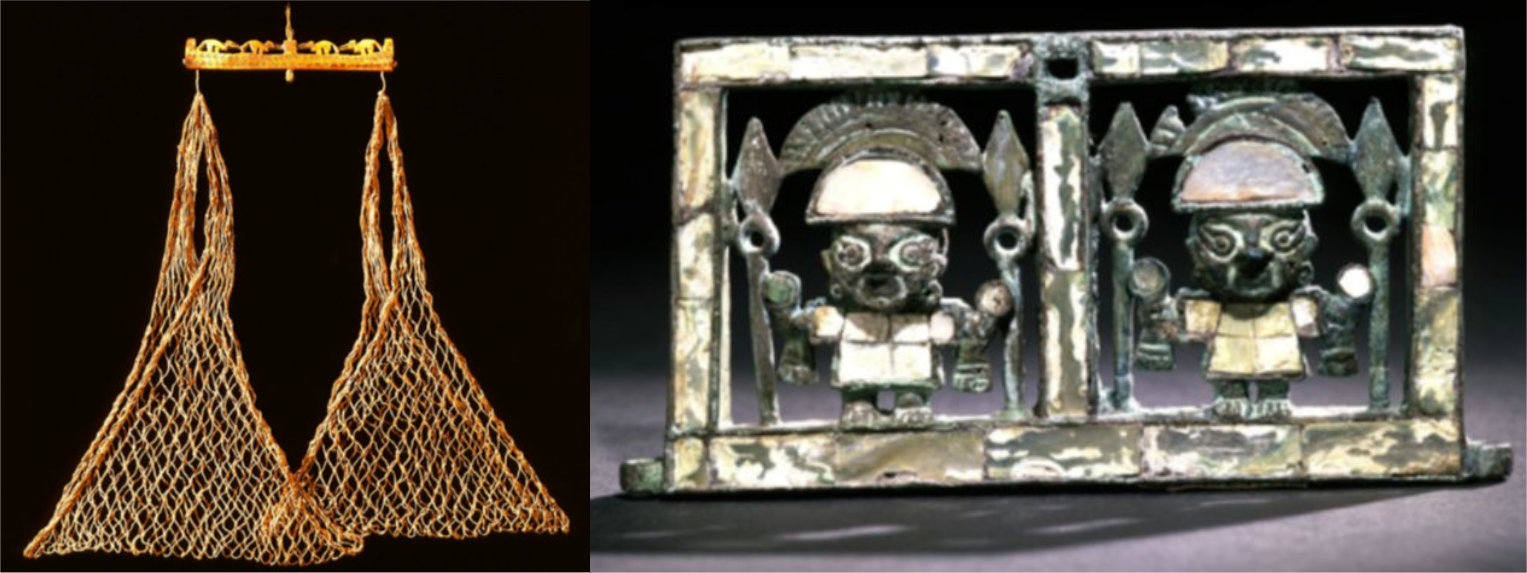
(Tap to Expand)
Concerning Engineers to build houses of cement, temples, towers, and highways:
 Mesoamerica: Ancient American cement was made using limestone, and has, thus far, only been found in Mesoamerica ... According to Mayan experts Michael D. Coe and Stephen Houston, it was not until the Late Preclassic period (300 BC-AD 250) that the Maya "quickly realized the structural value of a concrete-like fill made from limestone rubble" and lime-rich mud. This led to "an explosion of activity around 100 BC." One area where cement was used extensively was the city of Teotihuacán in central Mexico, which some Book of Mormon scholars consider to be in the land northward. [source: scripturecentral.org]
Concerning Artisans with Metal:
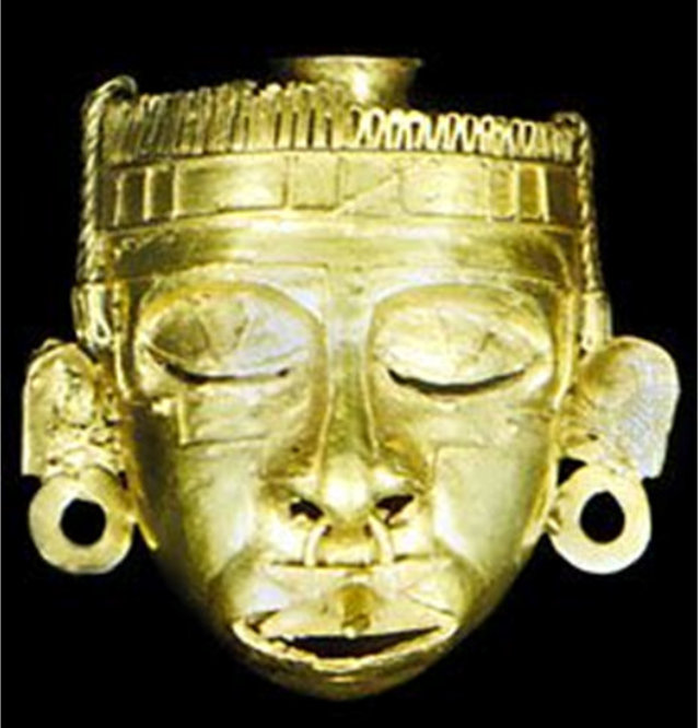
 In Mesoamerica, miniature, hollow lost-wax castings of the Mixtec goldsmiths in Mexico have never been surpassed in delicacy, realism, and precision; and some solid-cast frogs from Panama are so tiny and fine that they must be viewed through a magnifying glass to be appreciated.
Metal / Gold Artisanry (Mesoamerica)
(Tap to Expand)
Concerning Artisans with Stonework:
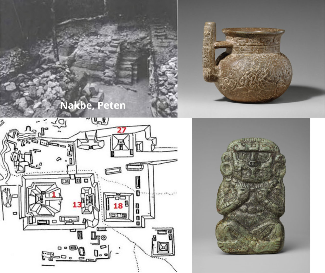
 In Mesoamerica, stonework examples showing a high degree of craftsmanship and ability to build structures with stone:
Stone Artisanry (Mesoamerica)
(Tap to Expand)
Concerning Fortifications:
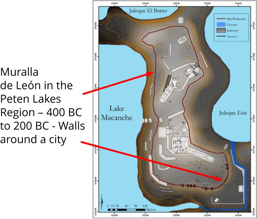
 In Guatemala, Muralla de Leon in the Peten Lakes Region - 400 BC to 200 BC - is an example of a walled city from the time of the Nephites.
Walled City (Mesoamerica)
(Tap to Expand)
×
![]()
