
- Introduction
- Test
- Grammar Structure
- Chiasmus
- Face of the Whole Earth
- Cardinal Points
- Hebrew Cosmology
- Mappa Mundi (9th Century BCE) - Earliest Known World Map
- Anaximander Map (610 - 546 BCE)
- Eratosthenes Map (276-194 BCE)
- Babylonia and Hebrew View of the World
- Named Seas in the Circular Ocean
- Conclusion
Introduction
There is a "sea north" and "sea south" mentioned in only one verse:HELAMAN 2:8 [3:8]: And it came to pass that they did multiply and spread, an did go forth from the land southward to the land northward, and did spread insomuch that they began to cover the face of the whole earth, from the sea south, to the sea north, from the sea west, to the sea east.
This seems a bit strange considering how often the sea east (36 verses) and sea west (40 verses) are mentioned. So, when encountering something that looks like geography, it needs to be determined if it is a metaphor or actual geography. Hebrew writing contains numerous "geographical" metaphors. A metaphor is a word or description used to represent something else and is not a real thing. Obviously, adding something "not real" that doesn't really exist to "real" geography creates "bad" geography. So, the first step in determining geography is to determine just what is actually geography and what is metaphor.Test
 Here is a test - of the geographical terms below that are found in the Book of Mormon, what is really geography and what is a metaphor? The most important questions are - How do you know and how can you prove your answer?
- Waters of Sebus (Alma 12:38 [17:26], 12:49 [17:34])
- Waters of Judah (I Nephi 6:8 [20:1])
- Waters of Mormon (Mosiah 9:33 [18:5], 9:38 [18:8], 9:65 [18:31], 9:66 [18:30], Alma 3:4 [5:3])
- Waters of Ripliancum (Helaman 2:4 [3:4], Ether 6:80 [15:8], 6:82 [15:10])
- Waters of Shiloah (II Nephi 9:44 [18:6])
Grammar Structure
The next step is to identify if any Hebrew grammatical structures exist in the text and if those grammatical structures indicate metaphor or geography. Hebraisms can often determine if a reference is a metaphor. There are three structures of interest in the verse:
- The phrase, "from the sea south, to the sea north, from the sea west, to the sea east" and the use of all four cardinal directions in the same sentence.
- The phrase "face of the whole earth" is a phrase that occurs in the Bible,
- Occurs 3 times in the Pentateuch which the Nephites had in their possession and
- Occurs 2 times in writings contemporary with the time that Lehi left Jerusalem, the book of Daniel and the book of Zechariah. Hence, Daniel and Zechariah used the phrase with the same understanding that Lehi had of it.
- A variation of the phrase, "face of the earth" occurs
- 13 times in the Pentateuch,
- 7 times in writings available to Lehi in the books of 1 Samuel, 1 Kings, Psalms, Isaiah, and Amos, and
- 7 times in writings contemporary with Lehi in the books of Jeremiah and Ezekiel.
- Helaman 2:8 [3:8] is part of a chiasmus (Hebrew poetry style) involving verses 2:3 [3:3] through 2:8 [3:8]
Chiasmus
Face of the Whole Earth
There are 3 variations of the phrase used in the Book of Mormon:
Alma 11:17 [16:11] Nevertheless, after many days, their dead bodies were heaped up upon the face of the earth, and they were covered with a shallow covering.
Or, the phrase can indicate the whole world, as in:Helaman 5:78 [14:22] Yea they shall be rent in twain, and shall ever after be found in seams and in cracks, and in broken fragments upon the face of the whole earth; yea, both above the earth and beneath.
Note: The use of the phrases to indicate both the entire earth or a localized or regional area agree with the Hebrew term erets (Strong's H776) which is the Biblical term used for earth and is used as either the entire earth or a localized of regional area. In reviewing the usage of these phrases in the Book of Mormon, "face of the whole earth" is used 7 times, including Helaman 2:8 [3:8]. In the 6 other verses, it is used to indicate the entire earth. The phrase "whole earth" is used 22 times, 20 times to indicate the entire earth and 2 times that are indeterminate (Alma 17:6 and Alma 18:8). In these verses, the earth shaking effect was felt locally but the "whole earth" usage in these verses might be attributable to the entire earth as these refer to encounters with angels and the power of God is attributable to the entire earth in the Old Testament. Only the phrase "face of the earth" is really used to indicate a regional or local area. The phrase exists in the Bible. In Genesis 8:52 (Inspired Version), it is used to describe the flood waters, "for the waters had not receded from off the face of the whole earth." This usage is of particular note because this verse does not appear in the KJV, so it is a consistent usage in another translation by Joseph Smith, Jr. The same phrase is used in Genesis 11:3 (IV), 11:4 (KJV) and, interestingly enough, is also used to describe the scattering of people across the earth as in Helaman 2:8 [3:8]. The phrase is used in Exodus 10:15, Daniel 8:5, and Zechariah 5:3. In all cases it is used to describe the entire earth. To be entirely correct, the Hebrew words are kol 'erets which is used in the Bible to mean either a local area or the entire earth. Where the Hebrew kol 'erets is translated into English as "face of the whole earth," it is used only to mean the entire earth and not a local area. The use of the phrase, "face of the whole earth," in Helaman 2:8 [3:8] would indicate that it means the entire earth. Is there anything else in the other points that would support this?Cardinal Points
Regarding point #1, the only verses that include all four cardinal compass points (north, south, east, and west) are II Nephi 12:65 [29:11], Mosiah 11:157 [27:6], Helaman 1:33 [1:31], Helaman 2:8 [3:8], III Nephi 1:19 [1:17], and III Nephi 9:49 [20:13]. With the exception of Helaman 1:33 [1:31] which talks about the Lamanites being surrounded on all four sides, all of the verses talk about the whole earth and use the four directions as a metaphor to indicate "everywhere".
In Helaman 2:8 [3:8], the cardinal directions use seas. If the seas in Helaman 2:8 [3:8] are indeed used as a metaphor, are there other references that support the metaphor? In II Nephi, there are some verses that can be used to substantiate the metaphor.
II NEPHI 7:11 [10:6]: And they who shall not be destroyed, shall be scattered among all nations.
II NEPHI 7:13 [10:8]: And it shall come to pass that they shall be gathered in from their long dispersion from the isles of the sea, and from the four parts of the earth;
II NEPHI 7:35 [10:20]: For the Lord has made the sea our path, and we are upon an isle of the sea.
II NEPHI 7:36 [10:21]: But great are the promises of the Lord unto those who are upon the isles of the sea;
II NEPHI 7:37 [10:21]: Wherefore, as it says isles, there must needs be more than this; and they are inhabited also by our brethren.
Isles are mentioned here and in other verses as metaphors for the extremities (the "four parts," "four corners," and "four quarters") of the earth. As mentioned in II Nephi 7:35 [10:20], the seas surround the isles. More about the "isles of the sea" (nagu) concept is presented later. Using the premise that the Bible can be referenced to help interpret grammar, the four compass points in the same verse are used to describe the extremities of the earth in four verses, the sides of a defined area or building in eight verses, and as a metaphor in a prophesy in one verse. Never are they used to describe actual geographical places. Further, in the Book of Mormon, if there is a clause after the phrase, "face of the whole earth," that phrase indicates the whole earth.Helaman 2:8 [3:8] And it came to pass that they did multiply and spread, an did go forth from the land southward to the land northward, and did spread insomuch that they began to cover the face of the whole earth, from the sea south, to the sea north, from the sea west, to the sea east.
Helaman 5:78 [14:22]Yea they shall be rent in twain, and shall ever after be found in seams and in cracks, and in broken fragments upon the face of the whole earth; yea, both above the earth and beneath.
3 Nephi 1:19 [1:17] Yea, in fine, all the people upon the face of the whole earth, from the west to the east, both in the land north and in the land south, were so exceedingly astonished, that they fell to the earth;
3 Nephi 4:14 [8:17] And thus the face of the whole earth became deformed, because of the tempests, and the thunderings, and the lightnings, and the quaking of the earth.
3 Nephi 4:15 [8:18] And behold, the rocks were rent in twain; yea, they were broken up upon the face of the whole earth, insomuch that they were found in broken fragments, and in seams, and in cracks, upon all the face of the land.
Helaman 5:78 [14:22] Yea they shall be rent in twain, and shall ever after be found in seams and in cracks, and in broken fragments upon the face of the whole earth; yea, both above the earth and beneath. Helaman 5:79 [14:23] And behold there shall be great tempests, and there shall be many mountains laid low, like unto a valley, and there shall be many places, which are now called valleys, which shall become mountains, whose height thereof is great.
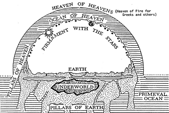
Hebrew Cosmology
One thing to keep in mind is that the 6th century Mesopotamian concept of the entire world is not the same as we have of it today. The diagram below illustrates the ancient Hebrew understanding of the entire world. An ocean surrounds the known world. There is also an underside to the earth as well as the top side - an analogy is a plate floating on a sea. This explains the use of the phrase, "both above the earth and beneath," in Helaman 5:78 [14:22]. See also Gen 1:6-9 for another description.
"This suggests that something akin to other ancient Near Eastern structures of the world was envisaged, in which as well as having a 'horizontal aspect' (surrounding the earth) the sea had a 'vertical aspect' (with waters above and below the earth)... The cosmic waters served as boundary for the habitable world. The term for this, ars, is ambiguous in Ugaritic, denoting both the surface and the underworld below (cf. the ambiguity of Heb. 'eres, though this term is often contrasted with tebel, not thus far attested in Ugaritic)." [Reference: Handbook of Ugaritic Studies]
Mappa Mundi (9th Century BCE) - Earliest Known World Map
As mentioned, the seas surround the world. Here is the earliest known map of the entire world. It is from Babylonia circa 9th century BC.
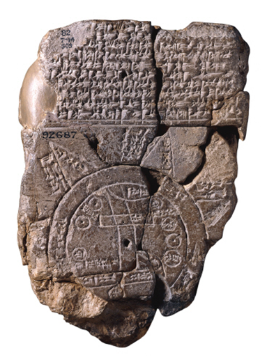 The Babylonian map of the world called the Mappa Mundi clearly shows the flat circular earth surrounded by water called the "Bitter River."
The circular band enclosing the continent is identified four times on the map as the marratu 'ocean'. The term marratu is a first-millennium synonym of tamtu 'sea'.
The five triangular areas radiating from the outer circle are identified as nagu. When complete, the map may have included as many as eight such nagu...
The term nagu in Assyrian and Babylonian Texts. In the first millennium, the geographic term nagu is common in Neo-Assyrian royal inscriptions, but rare in Late Babylonian royal inscriptions and literary texts.
In Late Babylonian royal inscriptions, the term nagu is used for distant unspecified areas. This sense of the word is appropriate for the World Map. The term nagu survives five times in published Late Babylonian royal inscriptions: four times in the inscriptions of Nebuchadnezzar and once in those of Nabonidus. In three of the Nebuchadnezzar examples, the nagu are located ina qereb tamti 'in the sea', suggesting that these nagu are islands.
Further evidence for nagu as islands in the sea may be found in the Gilgamesh Epic where nagu emerge at the edge of the sea as the waters of the flood recede.
This meaning of nagu ('island') may also be found in three Neo-Assyrian passages. In parallel passages from the inscriptions of Assurbanipal, the newly discovered land of Lydia is described as a nagu across the sea. [Reference: Mesopotamian Cosmic Geography]
The Babylonian map of the world called the Mappa Mundi clearly shows the flat circular earth surrounded by water called the "Bitter River."
The circular band enclosing the continent is identified four times on the map as the marratu 'ocean'. The term marratu is a first-millennium synonym of tamtu 'sea'.
The five triangular areas radiating from the outer circle are identified as nagu. When complete, the map may have included as many as eight such nagu...
The term nagu in Assyrian and Babylonian Texts. In the first millennium, the geographic term nagu is common in Neo-Assyrian royal inscriptions, but rare in Late Babylonian royal inscriptions and literary texts.
In Late Babylonian royal inscriptions, the term nagu is used for distant unspecified areas. This sense of the word is appropriate for the World Map. The term nagu survives five times in published Late Babylonian royal inscriptions: four times in the inscriptions of Nebuchadnezzar and once in those of Nabonidus. In three of the Nebuchadnezzar examples, the nagu are located ina qereb tamti 'in the sea', suggesting that these nagu are islands.
Further evidence for nagu as islands in the sea may be found in the Gilgamesh Epic where nagu emerge at the edge of the sea as the waters of the flood recede.
This meaning of nagu ('island') may also be found in three Neo-Assyrian passages. In parallel passages from the inscriptions of Assurbanipal, the newly discovered land of Lydia is described as a nagu across the sea. [Reference: Mesopotamian Cosmic Geography]
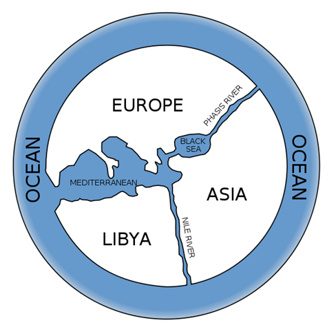
Anaximander Map (610 - 546 BCE)
Anaximander was one of the foremost map makers of his time. His maps represent the state-of-the-art in how the world was envisioned. This map again shows a circular world surrounded by a sea. It is included here since it was produced at roughly the time that Lehi left Jerusalem and shows that how the world was envisioned had not changed substantially from the Babylonian map.
Eratosthenes Map (276-194 BCE)
"The most enduring topographic feature to be situated at the limits of the oikoumene (the world known to the Greeks) was the circumambient Ocean. This concept of Ocean first found expression in Homer's Iliad. Homer described a mythological river Oceanus, flowing around the edges of a circular oikoumene, acting as the font of all terrestrial rivers (Homer's Iliad). Greek mapmakers adopted and developed the Oceanus concept. Anaximander and Hecataeus constructed maps of the world, which portrayed the oikoumene as framed by an all-encompassing Outer Sea, set in spatial opposition to the inner Mediterranean Sea.
Eratosthenes, when discussing the concept of a circumfluent Outer Ocean, found a midway point between theoretical speculation and Herodotus' argument in favour of empirical geographic knowledge. In the fragments of the Geography, it is asserted that enough of the world has been sailed around for it to be inferred reasonably that Ocean washes the oikoumene on all sides." [Reference: Reconstructing Eratosthene's Map of the World: A Study in Source Analysis]
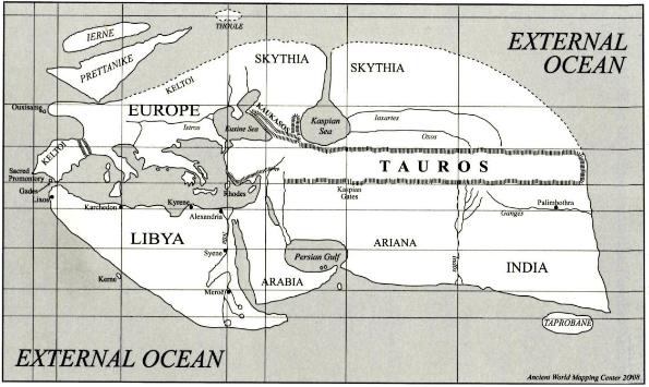 Eratosthenes, in his lifetime, did calculate the circumference of the world (as a sphere) fairly accurately. So, the perception of the world changed after Eratosthenes from a flat surface to a sphere. Eratosthenes' map is presented here as an example that for almost 400 years after Lehi left Jerusalem that the world was envisioned as having an ocean that surrounded the world.
Babylonia and Hebrew View of the World
Wayne Horowitz published a paper called, The Isles of the Nations: Genesis X and Babylonian Geography, in which he refers to the Babylonian Mappa Mundi map and states:
"Thus these nagu can be compared to the 'iyyam of Jer. xxv 22 or Isa. xli 2, 6, which were either islands or distant continental lands. Similarly, the general configuration of the map (central continent plus nagu) can be compared with the empire of Ahasuerus of Persia that consists of the land (ha^ares) and "isles of the sea" in Esther x 1. In fact, the term nagu itself offers nearly indisputable proof that Gen. x and the Babylonian map are based on a shared geographic world-view." [Reference: Studies in the Pentateuch, Volume 41]
This substantiates that the Hebrews and Babylonians shared a similar view of the world.
Note: Pre-scientific peoples in Africa, Australia, India, Egyptians, Sumer, Babylonia, Finno-Ugrians, Japan, China, South America, Mexico, and North America (Navaho, Zuni, Cherokee, Huron, Bilquala, Winebago, and Athapascans) regularly view the earth as a flat, circular disk. In no case do they view the world as a sphere. The phrase "circle of the earth" in Isaiah 40:22 is also used in Egyptian sources to mean a flat, circular disc. The Chinese, Japanese, Egyptians, and Babylonians viewed an ocean surrounding the world. [Reference: The Geographical Meaning of "Earth" and "Seas" in Genesis 1:10]
Named Seas in the Circular Ocean
In the Bible (Psalm 72:8, Zechariah 9:10, Amos 8:12, and Micah 7:12), "The phrase 'from sea to sea' refers to two specific bodies of water, but not to these bodies of water just in themselves but as representative parts of the 'two oceans on either side of the world' and the word, 'rivers,' (neharot) in 24:2b is known from Ugaritic to be simply a synonym of seas, and neharot is clearly used to mean seas in Ps 93:3.74' " [Reference: The Geographical Meaning of "Earth" and "Seas" in Genesis 1:10]
In Zechariah 14:8, the two seas on either side of the world are the former (East) sea and the hinder (West) sea.
The Bible contains a description of "yam sup." The term, "yam", means "sea" and there are no issues with this translation. However, there are various translations for "sup." It has been translated as "Red" and "Reed." However, the term, especially as used in Jeremiah 49:21, refers to the general sea that is the sea surrounding the earth towards the south. Translations of this sea to the south to the "Red Sea" come from the fact that this southern sea that surrounds the world comes up into what we know today as the Red Sea and the Persian Gulf.
"Yam sup is the equivalent of yam sop. This association has been suggested by Norman Snaith, who correctly argues that yam sup thus refers to 'that distant scarcely known sea away to the south, of which no man knew the boundary'. Thus, both the fragmentary Aramaic text from the Dead Sea Scrolls known as the Genesis Apocryphon (21.17-18) and the famous first-century A.D. Jewish historian Josephus (Antiquities 1.1.3) state that the Tigris and the Euphrates empty into the Red Sea. It is thus very clear that these ancients thought of the Red Sea as a continuous body of water that extended from the Red Sea through the Indian Ocean to the Persian Gulf and that included all connecting oceans to the south. Presumably the earlier Israelites likewise included in the designation yam sup all those connecting oceans to the south. The designation yam sup thus had both a geographical and a symbolic meaning. The "Sea of the End" means not just the sea at the physical end of the world but also the "place" where non-Creation or nonexistence begins." [Reference: Red Sea or Reed Sea?]
From Rabbi David Kimchi's Commentary upon the prophecies of Zechariah, and about Chapter 9:10, "And his dominion shall be from sea to sea," - The wise man, R. Abraham Aben Ezra, of blessed memory, has explained this to mean, "From the south sea, which is called the sea of Edom, to the northern sea, which is the ocean." [Reference: Rabbi David Kimchi's Commentary upon the prophecies of Zechariah
Note: Rabbi Kimhi's commentary of Zechariah 9:10 compliments the description in Zechariah 14:8 to identify the four seas, east, west, south, and north as the various descriptions for the seas encompassing the earth. As mentioned before, the Hebrews shared the same cosmology as the other Middle Eastern societies and these also had the same compass direction names for the four seas.
"Mazamua and Nairi are briefly mentioned in the general statement opening this unit. It delineates the scope of Shalmaneser's conquests by means of marking the seas at its ends: the western sea (Hatti and Amurru) the northern sea (Nairi), and eastern sea (Zamua)...In later accounts of the Babylonian campaigns of these years, a march to the southern 'Bitter River' is added. Thus, it is expected that a post-850 BCE account would add this toponym to such account, completing the series of the four seas in the four quarters of the world,...Considering the importance of great bodies of water in the Mesopotamian geographical concept, one would except that such an account would also have used the southern waters, completing a series of the four seas at the four ends of the land. So it is, for example, in the inscription that was composed after 841 and engraved on the colossal bulls at Calah." [Reference: Balawat Inscription of Shalmaneser III: Components, Structure, Message]
The four seas that surround the earth in Hebrew cosmology are metaphors. A real sea that extends beyond the known world (such as the Mediterranean Sea or the Red Sea/Persian Gulf/Indian Ocean) inherits the name of the metaphorical sea. This is evident with the Red Sea/Persian Gulf inheriting the name of the sea south (called the yam sup - "Sea of the End"). However, there is no requirement that any of the four seas extend into the known world. The sea north never existed in the Hebrew's known world in the Middle East. Likewise, the sea east did not exist - the Red Sea/Persian Gulf were considered to be the sea south. Note: there are some sources that translate the Red Sea/Persian Gulf as the sea east and not the sea south. It does not matter. They represent one metaphorical sea or the other, but not both.
Conclusion
The grammar in Helaman 2:8 [3:8] fits the pattern of a Hebrew "entire earth" metaphor. The phrase, "face of the whole earth," is used elsewhere in the Book of Mormon solely to describe the entire earth. The phrase is used in the Bible to describe the entire earth. It would be unusual for this one instance to mean otherwise. The reference to the four seas in the same verse is very consistent with a Hebrew entire earth metaphor that describes the seas that surround the earth. The four seas also describe the meaning of the "face of the whole earth." If the "face of the whole earth" indicates the entire earth, then the use of four seas to describe the "face of the whole earth" can only refer to the seas that surround the earth according to 6th century Hebrew cosmology.
If the seas were to be interpreted as real geography but existing beyond the known lands, then they are not a local description and again become a description of the entire earth according to Hebrew cosmology. This would be usage of the four seas to describe the areas beyond the known lands as seas surrounding the earth just as did the Hebrews, Babylonians, and Egyptians. So, even trying to interpret the seas as real geography, the description becomes once again one of the entire earth which describes the phrase, "face of the whole earth." If the phrase, "face of the entire earth" describes the entire earth, then the seas are the seas that surround the earth. This may seem like circular reasoning, but it does not matter if you try to interpret the seas as real geography or as a metaphor. The result is that they describe the seas that surround the earth.
According to 6th century Hebrew cosmology, the seas that surround the earth are metaphors. The confusion lies in that the sea west and sea east come within the Nephite's known world, just like the Mediterranean Sea (sea west) and Red Sea/Persian Gulf (sea south) came within the Hebrew's known world in the Middle East.
The lack of any evidence that would substantiate all four seas as real geography and the substantial evidence that the verse fits the Hebrew cosmology of the seas as a metaphor would indicate that the verse should be interpreted as a metaphor.