
There are several types of destructions described in the Book of Mormon. Each type of destruction can be associated with one or two possible geological forces that can produce the type of destructions that are described.
3 NEPHI 4:4 [8:3] Yea, for the time that there should be darkness for the space of three days, over the face of the land.
- Commentary: Several events can cause very low light levels. There is no additional information here that indicates how dark the "darkness" will be. However, the Hebrew word for darkness is <choshek> [H2822] which is used to describe the night, so very dark.
- Solar eclipse - these last only for a few minutes
- Volcanic eruption - there are records of some volcanic eruptions causing total blackness Forest fire - some heavy fires can cause low light levels - mixed with fog can further reduce light levels. New England's Dark Day occurred on May 19, 1780, when an unusual darkening of the daytime sky was observed over the New England states and parts of eastern Canada which was described 'If you'd woken up at noon you'd have believed it was midnight.' The primary cause of the event is believed to have been a combination of smoke from forest fires, a thick fog, and cloud cover.
- Very low clouds or very heavy storm clouds - if widespread and low enough, can reduce light levels
3 NEPHI 4:6 [8:5] And it came to pass in the thirty and fourth year, in the first month, in the fourth day of the month, there arose a great storm, such an one as never had been known in all the land;
3 NEPHI 4:7 [8:6] And there was also a great and terrible tempest; and there was terrible thunder, insomuch that it did shake the whole earth as if it was about to divide asunder; and there were exceeding sharp lightnings, such as never had been known in all the land.
- Commentary: Tempest in Hebrew is <zerem> [H2230] meaning rain shower, thunderstorm, downpour.
3 NEPHI 4:8 [8:8] And the city of Zarahemla did take fire; and the city of Moroni did sink into the depths of the sea, and the inhabitants thereof were drowned;
- Commentary: The most likely cause of fire is by a lightning strike. A city sinking is due to subsidence. Subsidence can be due to a landslide brought on by water-logged soil or due to an earthquake.
3 NEPHI 4:9 [8:10] And the earth was carried up upon the city of Moronihah, that in the place of the city thereof, there became a great mountain; and there was a great and terrible destruction in the land southward.
- Commentary: The only force that can carry soil upwards is an earthquake. The largest recorded vertical movement (throw) from an earthquake is 39 feet from a magnitude 7.5 earthquake in Sichuan, China in 2008. Given the limits of vertical movement from an earthquake, the Hebrew word for 'mountain' <har> [H2022] is likely using the definition option for a 'hill' rather than the modern interpretation to indicate a 'mountain' of considerable size. This verse indicates that the destruction occurred in the land southward in addition to the land northward (in 3 NEPHI 4:10 [8:12])
3 NEPHI 4:10 [8:12] But behold, there was a more great and terrible destruction in the land northward: for behold, the whole face of the land was changed, because of the tempests, and the whirlwinds, and the thunderings, and the lightnings, and the exceeding great quaking of the whole earth;
- Commentary: The Hebrew word for 'whirlwinds' <ca'ar> [H5591] can indicate a storm with winds or something like a tornado. given that 'tempest'(storm) is also used in the verse, it is likely that 'whirlwind' is referring to something different that a thunderstorm - like a tornado. The Hebrew word for 'quaking' <ra'ash> [H7493] refers to anything that quakes or shakes (undulates), so it could be referring to the ground shaking due to the thunder (see verse 4:7) or it could mean an earthquake given that it is described as 'exceeding great' which is a word combination in the Old Testament reserved for the 'largest' or 'most.' This verse indicates the shaking existed in the land northward as well as in the land southward (in 3 NEPHI 4:9 [8:10]).
3 NEPHI 4:11 [8:13] And the highways were broken up, and the level roads were spoiled, and many smooth places became rough, and many great and notable cities were sunk, and many were burned, and many were shook till the buildings thereof had fallen to the earth, and the inhabitants thereof were slain, and the places were left desolate;
- Commentary: Highways being broken up and smooth places becoming rough indicate ground movement indicating an earthquake. Hebrew for 'sunk' <taba`> [H2883] can be used for something being lowered (earthquake subsidence) or submerged (being sunk below water), both examples are given in the previous verses. For buildings to shake hard enough to fall would indicate an earthquake and not due to thunder.
3 NEPHI 4:12 [8:15] And there were some cities which remained; but the damage thereof was exceeding great, and there were many in them who were slain;
- Commentary: This verse is indicating destructions occurred over a large area.
3 NEPHI 4:13 [8:16] And there were some who were carried away in the whirlwind; and whither they went, no man knoweth, save they know that they were carried away;
- Commentary: Winds strong enough to carry people away can be from a hurricane or a tornado. Hurricanes do not directly cause fires as mentioned in the previous verses, so the whirlwind here is likely a tornado.
3 NEPHI 4:14 [8:17] And thus the face of the whole earth became deformed, because of the tempests, and the thunderings, and the lightnings, and the quaking of the earth.
- Commentary: Hebrew for 'deformed' is <mishchath> [H4893] meaning disfigured or marred. The word is used in the Old Testament for a hand or face being disfigured. There is no connotation that the end result is unrecognizable from what it looked like prior to the destructions, only that the landscaped had changed.
3 NEPHI 4:15 [8:18] And behold, the rocks were rent in twain; yea, they were broken up upon the face of the whole earth, insomuch that they were found in broken fragments, and in seams, and in cracks, upon all the face of the land.
- Commentary: The force that pulls rocks apart from each other would be an earthquake.
3 NEPHI 4:16 [8:19] And it came to pass that when the thunderings, and the lightnings, and the storm, and the tempest, and the quakings of the earth did cease--for behold, they did last for about the space of three hours; and it was said by some that the time was greater;
- Commentary: This description provides a duration for the combined thunderstorm and earthquake and any other activity - three hours.
3 NEPHI 4:17 [8:19] Nevertheless, all these great and terrible things were done in about the space of three hours; and then behold, there was darkness upon the face of the land.
3 NEPHI 4:18 [8:20] And it came to pass that there was thick darkness upon all the face of the land, insomuch that the inhabitants thereof who had not fallen, could feel the vapor of darkness;
3 NEPHI 4:19 [8:21] And there could be no light, because of the darkness; neither candles, neither torches; neither could there be fire kindled with their fine and exceeding dry wood, so that there could not be any light at all;
- Commentary: These verses introduce new geologic forces and conditions. After fires started by the tempest (storm), now no fire could be lit. Given the description that fire could not be lit with dry tinder, there must be some other force at work preventing fires. Also, there was a vapor that could be noticed. These two descriptions are very similar to what is called a Wazuka (gasses emitted from a volcanic fumarole) where the gasses (Carbon Dioxide - CO2 - and Sulphur Dioxide - SO2) are heavier than air and sink to the ground and can create a ground fog. The person in the below image shows that a Wazuka is not immediately harmful to humans, but the gasses near the ground would prevent a fire from being lit as the oxygen needed for combustion is displaced by the CO2 and SO2.
A Wazuka showing the vapor that is visible

(Tap to Expand - Image source here)
3 NEPHI 4:20 [8:22] And there was not any light seen, neither fire, nor glimmer, neither the sun, nor the moon, nor the stars, for so great were the mists of darkness which were upon the face of the land.
3 NEPHI 4:21 [8:23] And it came to pass that it did last for the space of three days, that there was no light seen; and there was great mourning, and howling, and weeping among all the people continually;
- Commentary: A severe thunderstorm would not last for 3 days. The only phenomenon that can cause darkness for 3 days are a volcanic eruption ash cloud or a meteor impact throwing significant amounts of dust into the air. Of these two options, the volcanic ash cloud is the most likely option.
3 NEPHI 4:31 [9:6] And behold, the city of Gilgal have I caused to be sunk, and the inhabitants thereof to be buried up in the depths of the earth;
- Commentary: To be 'sunk' indicates subsidence from an earthquake.
3 NEPHI 4:32 [9:7] Yea, and the city of Onihah, and the inhabitants thereof, and the city of Mocum, and the inhabitants thereof, and the city of Jerusalem, and the inhabitants thereof, and waters have I caused to come up in the stead thereof,
- Commentary: For waters to 'come up' either results from a hurricane tidal surge or a tsunami (caused by an earthquake). Given the descriptions of a storm with significant lightning and causing ground fires lasting 3 hours is not a description of a hurricane. The more likely of the two options would be a tsunami caused by an earthquake.
3 NEPHI 4:34 [9:8] And behold, the city of Gadiandi, and the city of Gadiomnah, and the city of Jacob, and the city Gimgimno, all these have I caused to be sunk, and made hills and valleys in the places thereof,
3 NEPHI 4:35 [9:8] And the inhabitants thereof have I buried up in the depths of the earth, to hide their wickedness and abominations from before my face, that the blood of the prophets and the saints should not come up any more unto me against them.
- Commentary: Again, these verses describe subsidence that would be caused by an earthquake and well as hills created by upthrust (throw) from an earthquake. To be buried could be a result of a landslide caused by the earthquake.
3 NEPHI 4:36 [9:9] And behold, that great city Jacobugath, which was inhabited by the people of the king of Jacob, have I caused to be burned with fire, because of their sins and their wickedness, which was above all the wickedness of the whole earth, because of their secret murders and combinations;
- Commentary: The cities of Jacobugath was located to the north of Zarahemla (also destroyed by fire likely started from lighting).
3 NEPHI 4:38 [9:10] And behold, the city of Laman, and the city of Josh, and the city of Gad, and the city of Kishkumen, have I caused to be burned with fire, and the inhabitants thereof, because of their wickedness in casting out the prophets, and stoning those whom I did send to declare unto them concerning their wickedness and their abominations;
- Commentary: These cities were also located north of, and in the vicinity of, Zarahemla
3 NEPHI 4:39 [9:11] And because they did cast them all out, that there were none righteous among them, I did send down fire and destroy them, that their wickedness and abominations might be hid from before my face, that the blood of the prophets and the saints whom I sent among them, might not cry unto me from the ground against them;
- Commentary: Sending down fire could refer to either the same fire that destroyed Sodom and Gomorrah or it could have been pyroclastic flows from a volcano. Both would come down from a higher elevation.
3 Nep 4:61 [10:9] And it came to pass that thus did the three days pass away.
3 Nep 4:62 [10:9] And it was in the morning, and the darkness dispersed from off the face of the land, and the earth did cease to tremble, and the rocks did cease to rend, and the dreadful groanings did cease, and all the tumultuous noises did pass away,
- Commentary: The earth trembling ended sometime before the 3 hours. The darkness lasted for three days and 'dispersed.' The Hebrew word for 'disperse' is <puwts> [H6327] meaning to scatter. The darkness did not leave suddenly. A volcanic ash cloud would match this description.
SUMMARY: The minimum number of geologic forces that can describe the destructions in 3 Nephi are:
- Severe Thunderstorm (Tempest) - Lightning (causing ground fires), Thunder (causing some shaking), and in some places can last for three hours or more.
- Tornadoes (Whirlwinds) - Have sufficient force to carry people away.
- Earthquake and tsunami - Causes quaking (buildings to fall), soil to subside (sunk down due to shaking), lift (earth carried up upon), general earth movement (smooth places to become rough and large areas to become deformed), and trigger tsunamis (water coming up).
- Volcano - There are documented examples of large magnitude (Mw7.5 and above) earthquakes triggering volcanic eruptions when the volcano was close to erupting. The ash cloud can cause darkness. Fumaroles and vents can emit carbon dioxide (CO2) and sulphur dioxide (SO2) that can produce a visible vapor that prevents fires from being lit. Volcanoes commonly discharge pyroclastic flows (send down fire).
Isthmus of Tehuantepec (Mexico) Model Assessment:
Severe Thunderstorms and Fires
April in the southern portion of Mexico and in Guatemala is the end of the dry season and the beginning of the rainy season. There are numerous thunderstorms that occur in April. The combination of dry conditions and lightning from storms produce many wildfires.
The image below is an example of a severe thunderstorm over southern Mexico and Guatemala including an approximate location for Zarahemla. The image shows significant lightning over the location for Zarahemla for over 5 hours.
The image below is an example of a severe thunderstorm over southern Mexico and Guatemala including an approximate location for Zarahemla. The image shows significant lightning over the location for Zarahemla for over 5 hours.
Severe Lightning Strikes in Mexico and Guatemala, April 30 to May 1, 2017
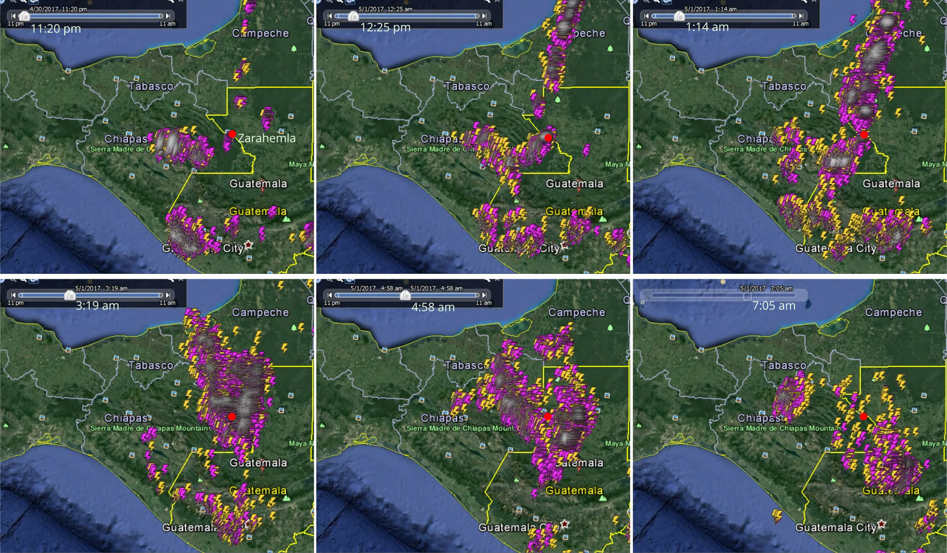
(Tap to Expand)
In Guatemala, fire season begins in February and continues until about May. The image below shows all of the fires burning on a specific day in April. It shows that fires do occur around the approximate locations for the cities that were destroyed by fire. Note: Roughly 20% to 40% (60 to 120) of the 300+ fires in the image were started by lightning and the others were started by farmers clearing their land.
Fires in Guatemala - April 11, 2013
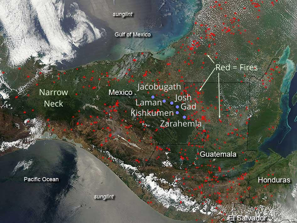
(Tap to Expand)
Tornadoes
Tornadoes that are not associated with hurricanes are rare in Guatemala, but they do occur. Some recent tornadoes associated with storms (not hurricanes or tropical storms) have touched down in Morales, Guatemala on 2/13/2022, Patzun on 3/4/2023 and another in Chimaltenango on 7/22/2020.
Earthquakes
Earthquakes in Mesoamerica can range up to very large Magnitude Mw7.0 to Mw7.9 with the fault line just off the Pacific coast able to generate Mw8.0+ earthquakes. The earthquake map below shows that earthquakes of Mw7.0 to Mw7.9 occur in the area between Zarahemla and Bountiful and in an area that can impact both the land northward and the land southward.
Earthquake Map for Mexico and Guatemala
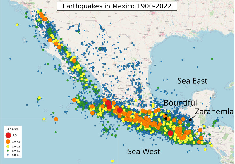
(Tap to Expand - Source)
Volcano
Mexico and Guatemala have several volcanoes. The one volcano that is closest to the Book of Mormon lands is El Chichon. El Chichon last erupted in 1982 (see the images below) and the satelite image proves that the ash cloud would cover the areas described in the Book of Mormon. Volcanic eruptions are measured on a Volcanic Explosivity Index (VEI) from 0 to 7 (supervolcano). The El Chichon eruption in 1982 was a VEI 5. For comparison, the eruptions of Mt St Helens in 1980 and Mt Vesuvius in 79 AD were also VEI 5 eruptions. Research [source] indicates that El Chichon erupted in 540 AD with a much larger VEI than the 1982 eruption and caused the Maya "hiatus" when they abandoned their lowland sites. In the image below, the peak of El Chichon in 1982 was smaller and contained within a larger caldera from a previous eruption when the peak was much larger, so it has a history of producing major eruptions. There is also research that indicates that El Chichon erupted around 30 AD +/- 20 years (at the time mentioned in the Book of Mormon).
El Chichon Volcano Eruption - 1982
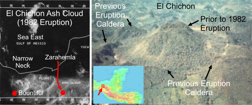
(Tap to Expand)
Heartland Model Assessment:
Severe Thunderstorms and Fires
The destructions in 3 Nephi occurred in the land of Zarahemla and Land of Bountiful. Those lands in the Heartland Model are Minnesota, Wisconsin, Michigan, Iowa, Illinois, Indiana, Ohio, and New York. Many severe thunderstorms occur in these states in the month of April.
Regarding wildfires started by lightning, statistics from the National Interagency Fire Center reports an average of 166 lightning caused wildfires per year (13 per month) for the years 2001 through 2024 in the Eastern Region of states (MN, WI, IA, IL, MO, MI, IN, OH, PA, WV, NY, RI, CT, NJ, DE, MD, NH, VT, MN, MA) that very closely matches the land of Zarahemla and land of Bountiful in the Heartland Model.
Tornadoes
The states composing the land of Zarahemla and Land of Bountiful do experience tornadoes.
United States Tornado Frequency - 1950 to 1995

(Tap to Expand)
Earthquakes
There is only one fault system near the land of Zarahemla and land Bountiful in the Heartland Model and that is the New Madrid fault. The fault produced three separate earthquakes ranging from an estimated Mw7.2 to Mw8.2. Research indicates that the New Madrid fault produced large earthquakes in 1811, 900 AD, 450 AD [reference], and 300 AD, and 2350 BC [reference]. Even if a large earthquake occurred on the New Madrid fault, the heavy to moderate damage would not extend to Zarahemla or to the land Bountiful. There were no large earthquakes from the fault near the time of Jesus' crucifixion (33 AD).
New Madrid Earthquake Mw7.7
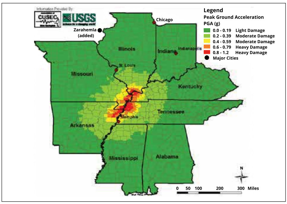
(Tap to Expand)
Also, the north countries in the Heartland Model were located near the gap between Lake Erie and Lake Ontario, The only sizable fault in this area is the Clarendon-Linden fault system (CLFS). This is a strike / slip fault that does not produce vertical ground movement. The largest earthquake measured on the CLFS was a Mw4.9 in 1929. An earthquake of this small magnitude does not describe the destructions in 3 Nephi.
Volcano
There was no volcanic activity in the Heartland Model lands during the time of the Jaredites or Nephites.
Candidate locations with Significant Geologic Forces:
These locations meet the basic requirements for having at least significant earthquake geologic forces. They may have one or more other geologic forces:
- Large Storms with Lightning (causing wildfires)
- Tornadoes
- Earthquakes (and tsunamis)
- Volcanoes
Baja California
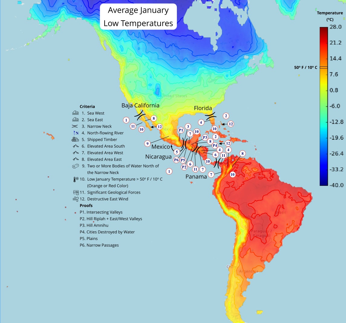
(Tap to Expand)
Click here for more information on the Baja California location.
Italy
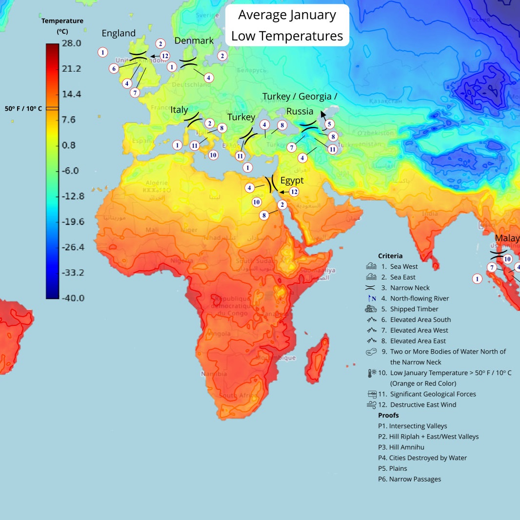
(Tap to Expand)
Click here for more information on the Italy location.
Mexico
(Tap to Expand)
Click here for more information on the Mexico location.
Nicaragua
(Tap to Expand)
Click here for more information on the Nicaragua location.
Panama
(Tap to Expand)
Click here for more information on the Panama location.
Russia
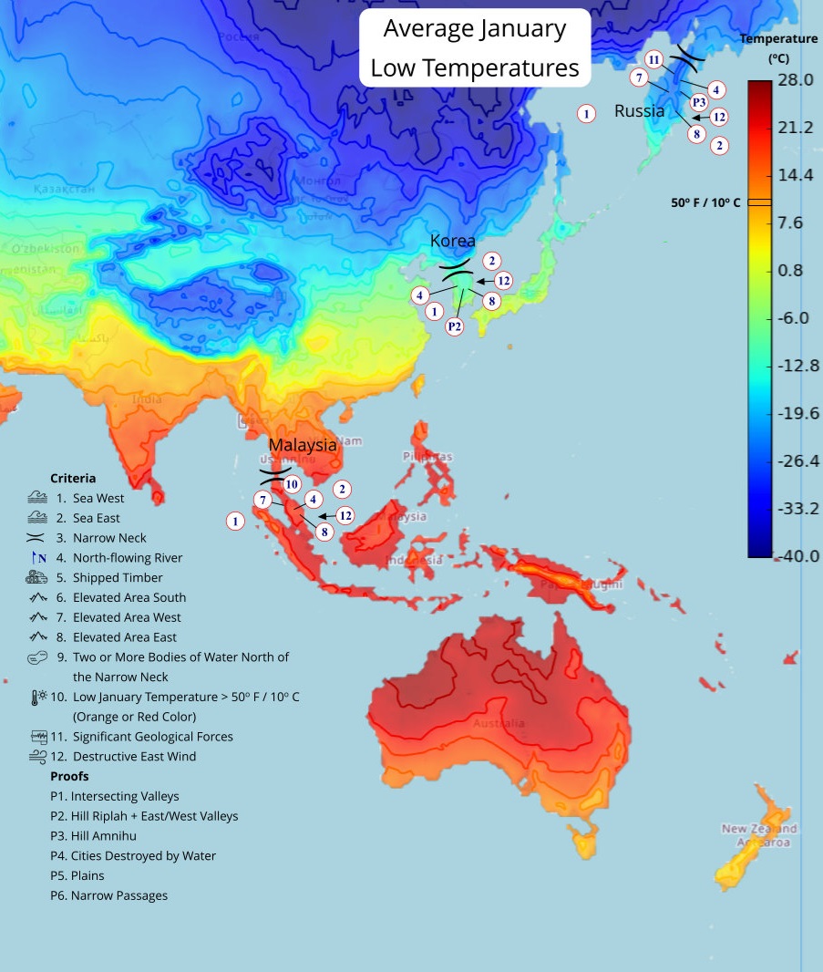
(Tap to Expand)
Click here for more information on the Russia location.
Turkey
(Tap to Expand)
Click here for more information on the Turkey location.
Turkey/Georgia/Russia
(Tap to Expand)
Click here for more information on the Turkey/Georgia/Russia location.
×
![]()