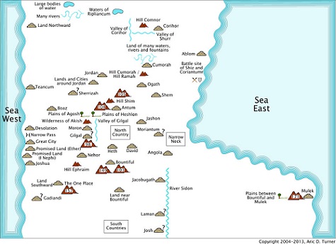
The purpose of an internal map is to represent the geography according to the information in the Book of Mormon. The benefit of an internal map is that it can be used as a study aid without any controversy associated with putting the locations on the world globe. To create a consistent internal map of the Book of Mormon geography, each place on the map must be located in such a way that it represents the information provided in the Book of Mormon. This information consists of relationships of one place being north, south, east and/or west of other places. You should be able to read any verse that contains geographical information and it should agree with the locations on the internal map. Verses with geographical information are discussed in the Internal Map Commentary.
The internal maps contain wildernesses that are numbered. The names that correspond to the numbers come from the numbered list of places found in the Internal Map Commentary. The names are not put on the internal maps for brevity.
Question marks near the places on the internal maps indicate places where there is insufficient information regarding their location. They are placed according to Occam's Razor (which says the simplest solution is generally the right solution).
The internal maps of New World places are presented in four overlapping sections:
The internal maps of the Old World places are presented in three sections:
Note: Many places around the Old World are known from current place names and they are located as close as possible to known locations.
Due to the nature of geographical information that describes relationships between places, more than one place can be discussed in each verse. In these cases, the commentary is included with every place.
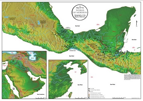
These two maps below are the same map, but different physical sizes. All man-made reservoirs have been removed and the river courses are as close to their true courses from around early B.C. dates as archaeology information permits. It turns out that Mesoamerica is like a paper plate where the outside edges are rising. Rivers that were spread apart before 1 A.D. are having their river courses and mouths in the Tabasco and Campeche regions move their courses towards a central point on the Bay of Campeche coast. A number of archaeological sites are now located on dry river beds that once used to be major navigable rivers.
Only the named mountains and hills are included on these maps for brevity. However, if you compare the ridges and wildernesses on the internal maps to the hilly and mountainous areas on these maps, you will see that all of the unnamed wildernesses correspond to physical hilly and mountainous terrain. So, I feel justified that the discovery of wildernesses mean hilly and mountainous terrain is a correct assumption.
The Travel Maps show the peoples' travels on both the internal map and the external map. You may notice from the travel maps that most of the travel south of the south wilderness is very often in an east/west direction - exactly what the terrain easily permits.
The maps in this section display the movements of people in the Book of Mormon. Maps of places alone only show part of the environment that these people lived in. Showing how they moved from place to place provides insight about their environment and explains the interactions between the Nephites and Lamanites.
These links display the travels in chronological order on both the internal maps and world location maps.


