Map 1 (Amlicite and Nephite armies to Hill Amnihu)
Map 2 (Amlicite and Nephite armies from Minon to Hermounts)
Map 3 (Alma from Zarahemla to Gideon)
Map 4 (Lamanite army to Ammonihah)
Map 5 (Mosiah's sons to lands south)
Map 6 (Mosiah's sons to Ishmael)
Map 7 (Lamanites to Ammonihah)
Map 8 (Ammon and brethren from Nephi to Zarahemla)
Map 9 (Korihor from Zarahemla to Jershon)
Map 10 (Alma, Ammon, etc. from Zarahemla to Melek)
Map 11 (Moroni and Lamanites from Jershon to the valleys east and west)
Map 12 (Details of the battle around the valleys east and west)
Map 13 (Moroni, Amalilkiah, etc from Zarahemla to Nephi)
Map 14 (Lamanites to Ammonihah and Noah)
Map 15 (People of Morianton and Lehi to Bountiful)
Map 16 (Lamanites to Moroni)
Map 17 (Animals from land northward)
Map 18 (Lamanites to the sea West south)
Map 19 (Teancum to Mulek)
Map 20 (Moroni and Teancum to Mulek)
Map 21 (Nephites to Judea)
Map 22 (Gid and Helaman from Antiparah to Cumeni)
Map 23 (Battle for Manti)
Map 24 (Moroni from Zarahemla to Nephihah)
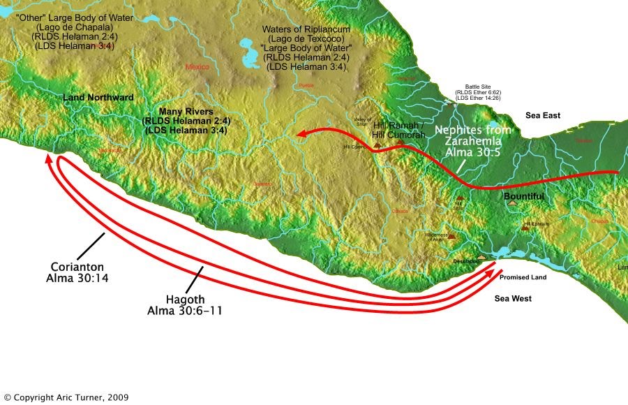
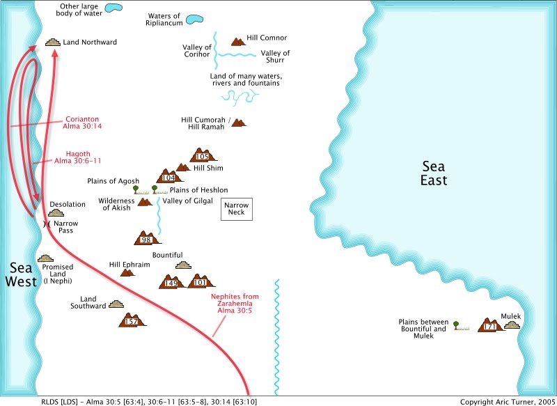
Map 25 (Corianton and Hagoth to the land Northward)
Map 1 (Amlicite and Nephite armies to Hill Amnihu)
Map 2 (Amlicite and Nephite armies from Minon to Hermounts)
Map 3 (Alma from Zarahemla to Gideon)
Map 4 (Lamanite army to Ammonihah)
Map 5 (Mosiah's sons to lands south)
Map 6 (Mosiah's sons to Ishmael)
Map 7 (Lamanites to Ammonihah)
Map 8 (Ammon and brethren from Nephi to Zarahemla)
Map 9 (Korihor from Zarahemla to Jershon)
Map 10 (Alma, Ammon, etc. from Zarahemla to Melek)
Map 11 (Moroni and Lamanites from Jershon to the valleys east and west)
Map 12 (Details of the battle around the valleys east and west)
Map 13 (Moroni, Amalilkiah, etc from Zarahemla to Nephi)
Map 14 (Lamanites to Ammonihah and Noah)
Map 15 (People of Morianton and Lehi to Bountiful)
Map 16 (Lamanites to Moroni)
Map 17 (Animals from land northward)
Map 18 (Lamanites to the sea West south)
Map 19 (Teancum to Mulek)
Map 20 (Moroni and Teancum to Mulek)
Map 21 (Nephites to Judea)
Map 22 (Gid and Helaman from Antiparah to Cumeni)
Map 23 (Battle for Manti)
Map 24 (Moroni from Zarahemla to Nephihah)
Map 25 (Corianton and Hagoth to the land Northward)


Verses 

Alma 30:5 And it came to pass that in the thirty and seventh year of the reign of the Judges, there was a large company of men, even to the amount of five thousand and four hundred men, with their wives and their children, departed out of the land of Zarahemla, into the land which was northward.
Alma 30:6 And it came to pass that Hagoth, he being an exceeding curious man, therefore he went forth, and built him an exceeding large ship, on the borders of the land Bountiful, by the land Desolation, and launched it forth into the west sea, by the narrow neck which led into the land northward.
Alma 30:7 And behold there were many of the Nephites who did enter therein, and did sail forth with much provisions, and also many women and children; and they took their course northward.
Alma 30:8 And thus ended the thirty and seventh year.
Alma 30:9 And in the thirty and eighth year, this man built other ships.
Alma 30:10 And the first ship did also return, and many more people did enter into it; and they also took much provisions, and set out again to the land northward.
Alma 30:11 And it came to pass that they were never heard of more. And we suppose that they were drowned up in the depths of the sea.
Alma 30:14 And it came to pass in the thirty and ninth year of the reign of the Judges, Shiblon died also, and Corianton had gone forth to the land northward, in a ship, to carry forth provisions unto the people who had gone forth into that land;
World Location