HELAMAN 2:7 [LDS 3:7] And there being but little timber upon the face of the land, nevertheless the people who went forth became exceeding expert in the working of cement: therefore they did build houses of cement, in the which they did dwell.
HELAMAN 2:9 [3:9] And the people who were in the land northward, did dwell in tents, and in houses of cement, and they did suffer whatsoever tree should spring up upon the face of the land, that it should grow up, that in time they might have timber to build their houses, yea, their cities and their temples, and their synagogues, and their sanctuaries, and all manner of their buildings.
HELAMAN 2:10 [3:10] And it came to pass as timber was exceeding scarce in the land northward, they did send forth much by the way of shipping; and thus they did enable the people in the land northward, that they might build many cities, both of wood and of cement.
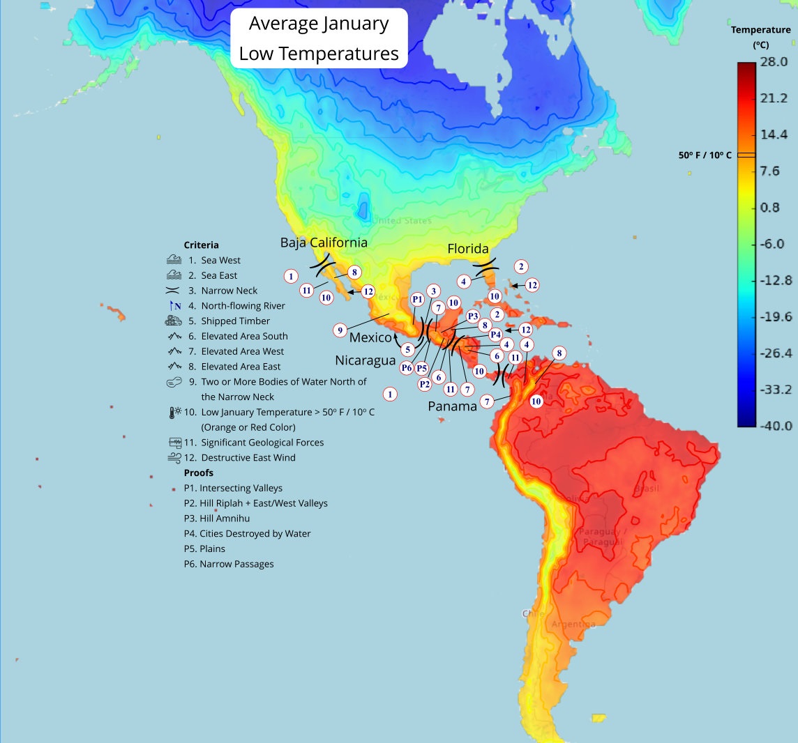
From this description, the area south of the land northward shipped timber to the land northward. The land northward begins just north of the narrow neck, so an area around the narrow neck or even further south needs to have timber suitable for using in cement (i.e. pueblo-style) house construction. The wood beams (vigas) in pueblo construction average between 6 inches and 10 inches in diameter and are 15 feet long.
Isthmus of Tehuantepec (Mexico) Model Assessment:
A detailed description of shipped timber in the Mexico Narrow Neck location is located here.
Heartland Model Assessment:
There are no locations in the Eastern United States east of the Mississippi River and adjacent to a ship-navigable body of water where there is little-to-no timber. Any location where a sea West from a "narrow neck" (indicating the land northward is north of a narrow neck) can be found has as much, if not more, timber north of the "narrow neck" than south of it. The Heartland model specifies three narrow necks (here). The navigable waters that extend from the narrow necks southward to an area northward are Lake Michigan and Lake Erie (for narrow neck #2), although Lake Michigan was not ship-navigable due to the Grand Kankakee marsh covering the entire southern end of the lake and leaving no place to launch a ship. The narrow necks #1 and #3 do not have a ship-navigable water from the narrow necks northward to any place north of the land Desolation (on the maps) that would be the land northward. All three of these narrow necks have sufficient timber north of the narrow necks to not need additional timber from the southern areas.
The Heartland Model is also inconsistent about the location of the land northward - one reference [here] mentions, 'the land northward was the Niagara peninsula and further north and west of there' while the maps [here] show that location as being the land Desolation. Another map reference [here] shows a map with the land northward south of Lake Erie (and the Niagara peninsula). There is no discussion why timber would need to be shipped from Lake Michigan through Lake Huron and into Lake Erie, or, where the land northward might be reached from Lake Michigan. Given the inconsistencies in the descriptions of the land northward and none of the possible areas had any lack of timber, the Heartland Model is inconsistent with the Book of Mormon description for shipped timber.
Candidate Shipped Timber locations:
These locations meet the requirement of having a ship-navigable sea or body of water where timber exists south of the narrow neck and with little-to-no timber north of the narrow neck.
Mexico
(Tap to Expand)
Click here for more information on the Mexico location.
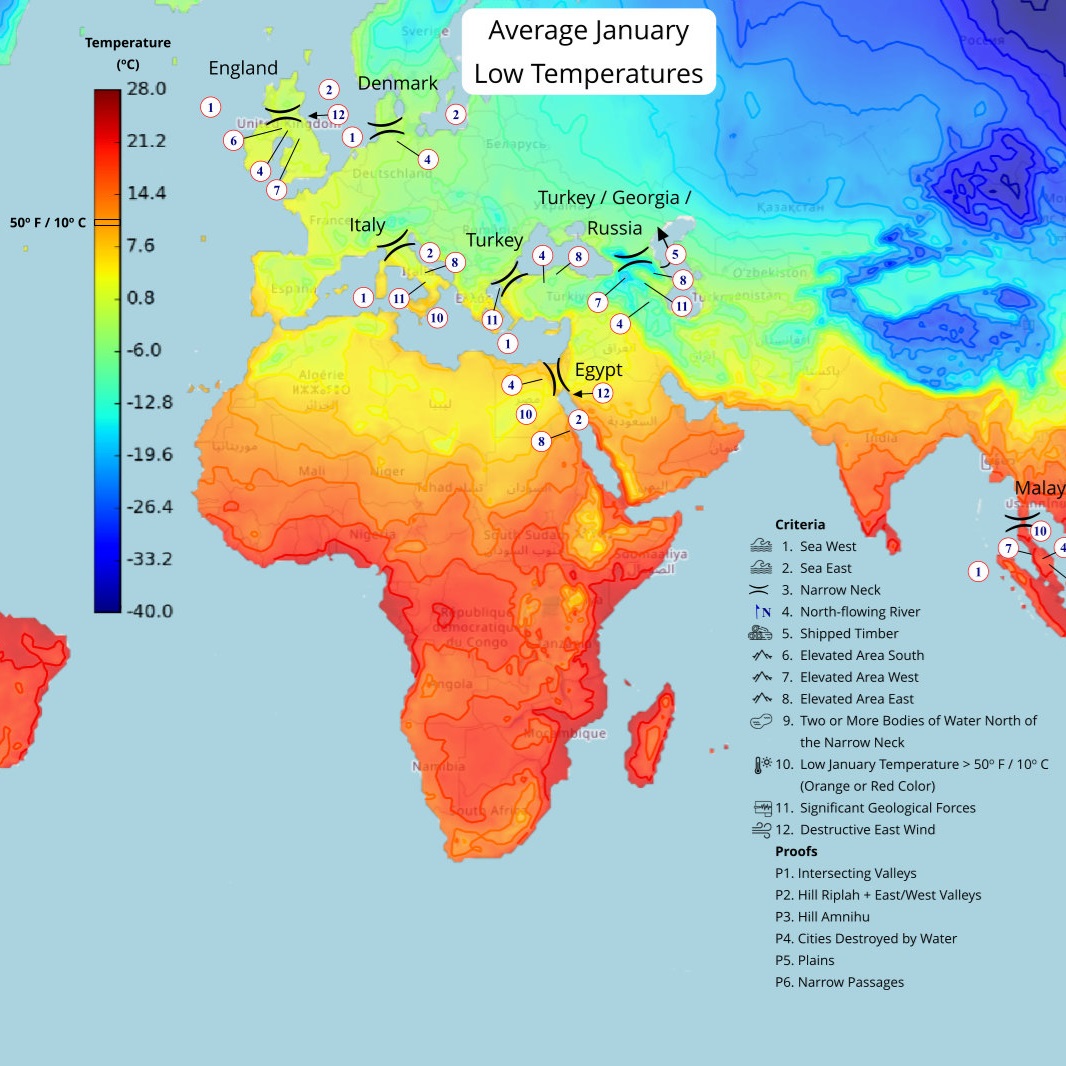
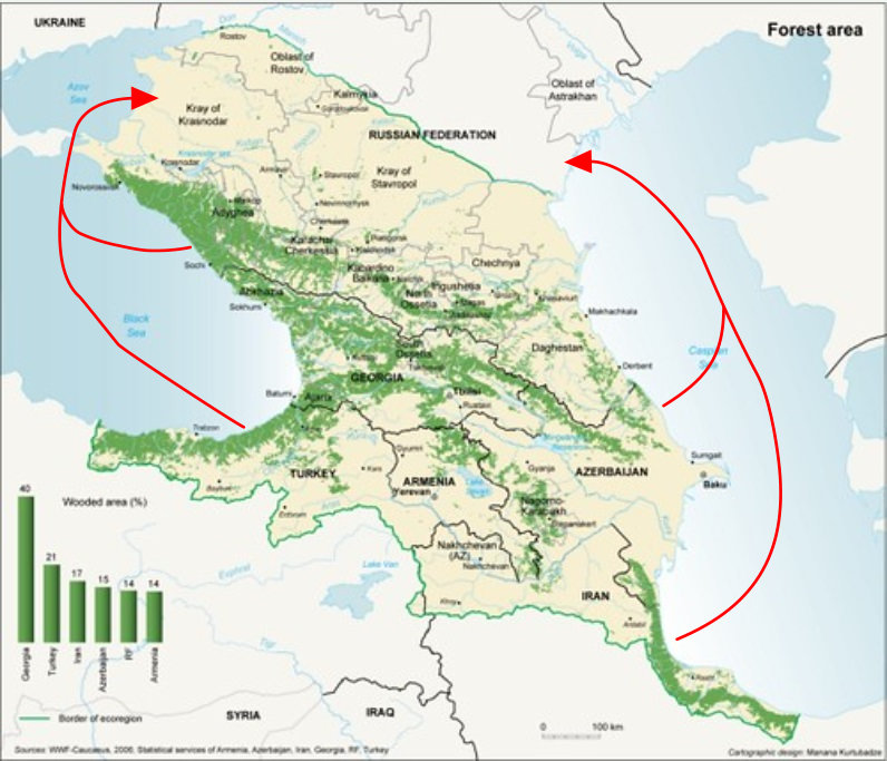
Turkey/Georgia/Russia
(Tap to Expand)
(Tap to Expand)
This map shows potential travel routes across bodies of water from areas with timber to to the land north of the narrow neck located in Turkey / Georgia / Russia.