ALMA 13:68 [22:27]: And it came to pass that the king sent a proclamation throughout all the land, amongst all his people who were in all his land, who were in all the regions round about, which was bordering even to the sea, on the east, and on the west, and which was divided from the land of Zarahemla by a narrow strip of wilderness,
ALMA 13:69 [22:27] Which ran from the sea east, even to the sea west, and round about on the borders of the sea-shore, and the borders of the wilderness which was on the north, by the land of Zarahemla, through the borders of Manti, by the head of the river Sidon, running from the east towards the west; and thus were the Lamanites and the Nephites divided.
- Commentary: These verses describe a narrow strip of wilderness (the south Wilderness) as running from the sea East to the sea West and the head of the river Sidon lies in this course from the east to the west.
ALMA 16:80 [31:3]: Now the Zoramites had gathered themselves together in a land which they called Antionum, which was east of the land of Zarahemla, which lay nearly bordering upon the seashore, which was south of the land of Jershon, which also bordered upon the wilderness south,/span which wilderness was full of the Lamanites.
- Commentary: This verse describes a sea that is located by the south and east portions of the land. The south wilderness is located south of the narrow neck.
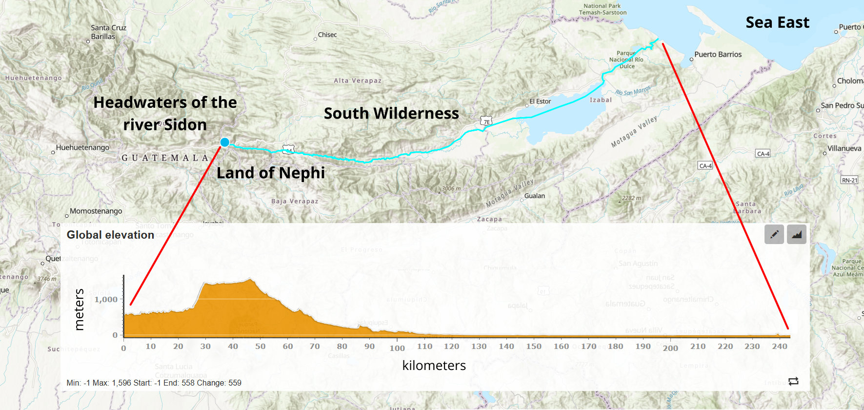
ALMA 22:8 [50:8]: And the land of Nephi did run in a straight course from the east sea to the west.
- Commentary: This verse describes the general shape of the land of Nephi. A 'straight course' not only means a straight line, but the Hebrew word for 'course' is mecillah [Strong's H4546] meaning path, road, or highway, indicating the course can be traveled. The straight line indicates the shape of the land of Nephi is oblong and was longer along the east-west axis than the north-south axis. Now, there were lands between the land of Nephi and the sea East, such as the lands of Jerusalem, Moroni, Antionum, and Mormon. So, the description that the land of Nephi extended to the sea indicates some feature that extends across political boundaries. There are a few other examples in the Book of Mormon of lands described that are 'larger' than their political boundary, for example the land of Zarahemla, the south countries, and land of Bountiful have descriptions that extend beyond their political boundaries. This indicates some feature that extends beyond a political boundary.
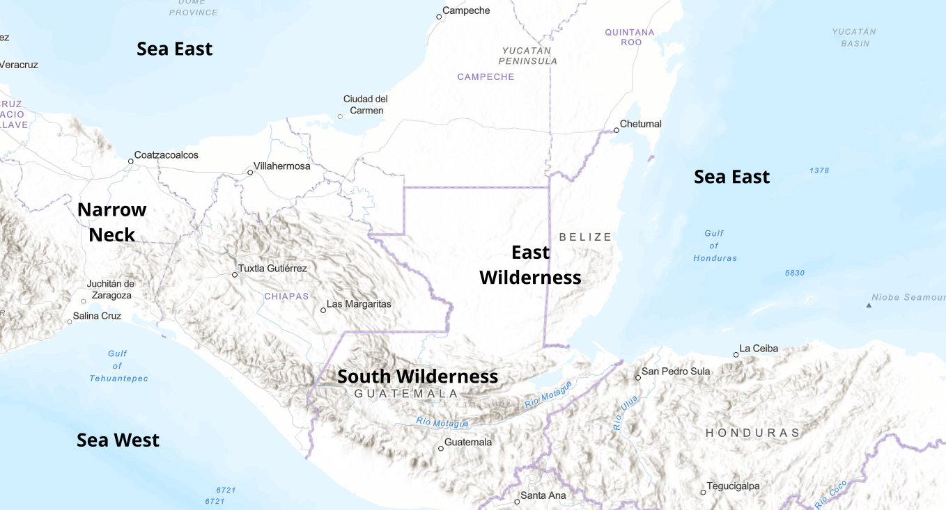
ALMA 22:9 [50:9]: And it came to pass that when Moroni had driven all the Lamanites out of the east wilderness, which was north of the lands of their own possessions, he caused that the inhabitants who were in the land of Zarahemla, and in the land round about, should go forth into the east wilderness, even to the borders, by the sea-shore, and possess the land.
- Commentary: The East Wilderness has a seashore on the east side of the wilderness. This would be the Sea East.
ALMA 22:14 [50:13]: And it came to pass that the Nephites began the foundation of a city; and they called the name of the city Moroni; and it was by the east sea; and it was on the south by the line of the possessions of the Lamanites.
- Commentary: The city of Moroni is by the Sea East. The phrase 'on the south' indicates it was on the southern parts of the lands of the Nephites. The phrase 'by the line of the possessions of the Lamanites' refers to the South Wilderness. So, the land of Moroni is next to the South Wilderness. Again, the south wilderness is south of the narrow neck.
ALMA 23:32 [51:26]: And thus he went on, taking possession of many cities: the city of Nephihah, and the city of Lehi, and the city of Morianton, and the city of Omner, and the city of Gid, and the city of Mulek, all of which were on the east borders, by the sea-shore.
- Commentary: These cities are listed in geographical order, so they share a border with the cities listed next to them. Combined with the other information about the city of Nephihah, the city of Nephihah is between the city of Moroni and the city of Lehi, yet further inland. Since the land of Moroni joins the south border of the land of Lehi, the cities listed here extend the opposite direction. So, they are listed from south to north. Also, these cities are by the sea East shore and south of the narrow neck.
III NEPHI 4:8 [8:8]: And the city of Zarahemla did take fire; and the city of Moroni did sink into the depths of the sea, and the inhabitants thereof were drowned;
III NEPHI 4:29 [9:4]: And behold, that great city Moroni have I caused to be sunk in the depths of the sea, and the inhabitants thereof to be drowned.
III NEPHI 4:32 [9:7]: Yea, and the city of Onihah, and the inhabitants thereof, and the city of Mocum, and the inhabitants thereof, and the city of Jerusalem, and the inhabitants thereof, and waters have I caused to come up in the stead thereof,
- Commentary: These cities are located on the southern portion of the lands next to the sea East. The water coming up refers to a tsunami since the northern cities on the coast did not experience the rising waters (a storm surge from a hurricane would have impacted all of the cities).
Isthmus of Tehuantepec (Mexico) Model Assessment:
The east coast of Belize and northern Honduras fit all of the criteria for the sea East. The Belize mountains fit the description of the east wilderness. The mountainous area in Guatemala that runs east/west terminates near the eastern sea coast near Livingston. There is also a scientific study that confirms that the southern portion of the coast near Livingston and northern Honduras experience tsunamis while the coast of Belize is not impacted by tsunamis due to the undersea topology.
Sea East (Mexico)
(Tap to Expand)
With a description such as in Alma 22:8, one feature that extends across multiple political boundaries are river systems. So, it is consistent with the description in the Book of Mormon that the river system of the land of Nephi (Potochic River) extends from the west to the sea East. Other lands in the Book of Mormon that are described as a 'larger' land that encompasses multiple lands or polities include the land of Zarahemla (river Sidon / Usumacinta river and the Rio Pasion river basin), the south Countries (upper Grijalva River basin and maybe the lower basin as well), and land Bountiful (Rio Coatzacoalcos river basin). The Potochic River and Lago Izabal are a straight line and the elevation gradient is easy to travel - a road currently runs through the upper valley of the Potochic River. The land of Nephi was in proximity to the head of the river Sidon (Usumacinta River) and it's possible to travel from the Usumacinta River system to the Potochic River system along a straight course. The Isthmus of Tehantepec narrow neck location satisfies all descriptions of the sea East.
Land of Nephi Course to the Sea East (Mexico)
(Tap to Expand)
Heartland Model Assessment:
The Heartland Model names two bodies of water as the sea East - Lake Ontario ('Lake Ontario, or "Sea East" as identified by Joseph Smith' - reference) and the Atlantic Ocean ('Clearly the East Sea is represented by the Atlantic Ocean' - reference). The maps show Lake Ontario and the Atlantic Ocean as being the sea East [reference].
With regards to Lake Ontario being the sea East, the cities of Mulek, Gid, Omni, Morianton, Lehi, Moroni, Jerusalem, Mocum, and Onihah are located on the sea East coast south of the narrow neck. Hill Cumorah is located north of the narrow neck. There is no part of Lake Ontario that is south of the hill Cumorah in New York. So, either:
- The hill Cumorah in New York is not the hill Cumorah in the Book of Mormon, or
- Lake Ontario is not the sea East in the Book of Mormon
Where the Heartland Model places the 'straight course' of the land of Nephi to the sea East begins at a location the model names as the head of the river Sidon (see the map) and extends to the Atlnatic Ocean. There is a logical fallacy used regarding the Heartland Model depiction of the head of the river Sidon (see Head of the River Sidon) and the Mississippi River as the River Sidon (see North Flowing River). So, the 'straight course' cannot be evaluated as it is depicted.
Alma 13:68-69 describes the south wilderness (narrow strip of wilderness) running all the way from the sea East to the sea West with the head of the river Sidon within this east to west course. The only description of the south wilderness in the Heartland Model (see the map with the narrow strip of wilderness) is at the southern shore of Lake Michigan and it does not contain the head of the river Sidon nor does it run to the sea East. Lake Michigan does not meet the criteria for the sea West (see sea West) and the narrow strip of wilderness does not meet the criteria needed for the sea East or the head of the river Sidon, so the Heartland Model does not describe geography that satisfies Alma 13:68-69 for the sea East.
Candidate Sea East locations:
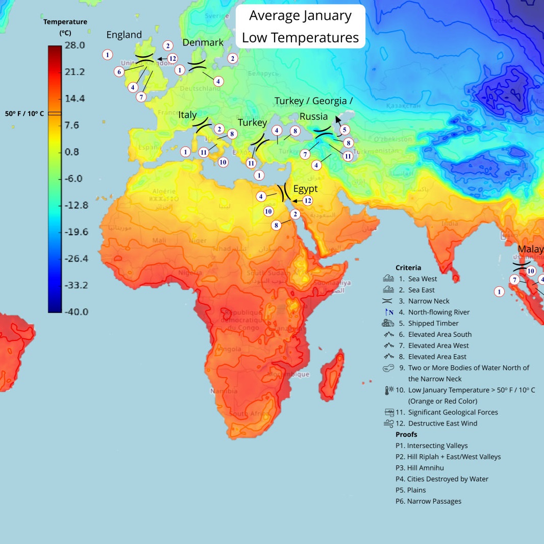
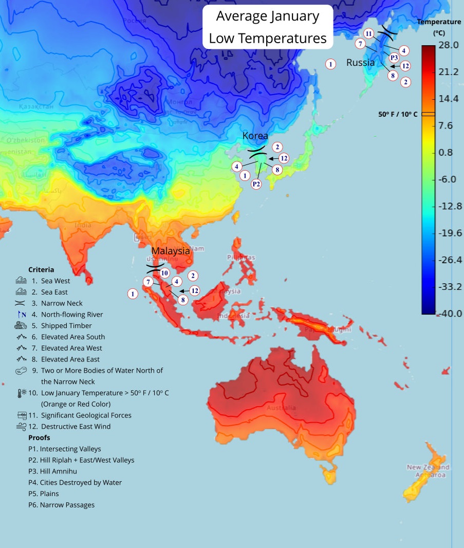
These locations meet the basic requirements for being a sea East. Note: The narrow neck locations all have a navigable body of water to their east
Criteria for the sea East:


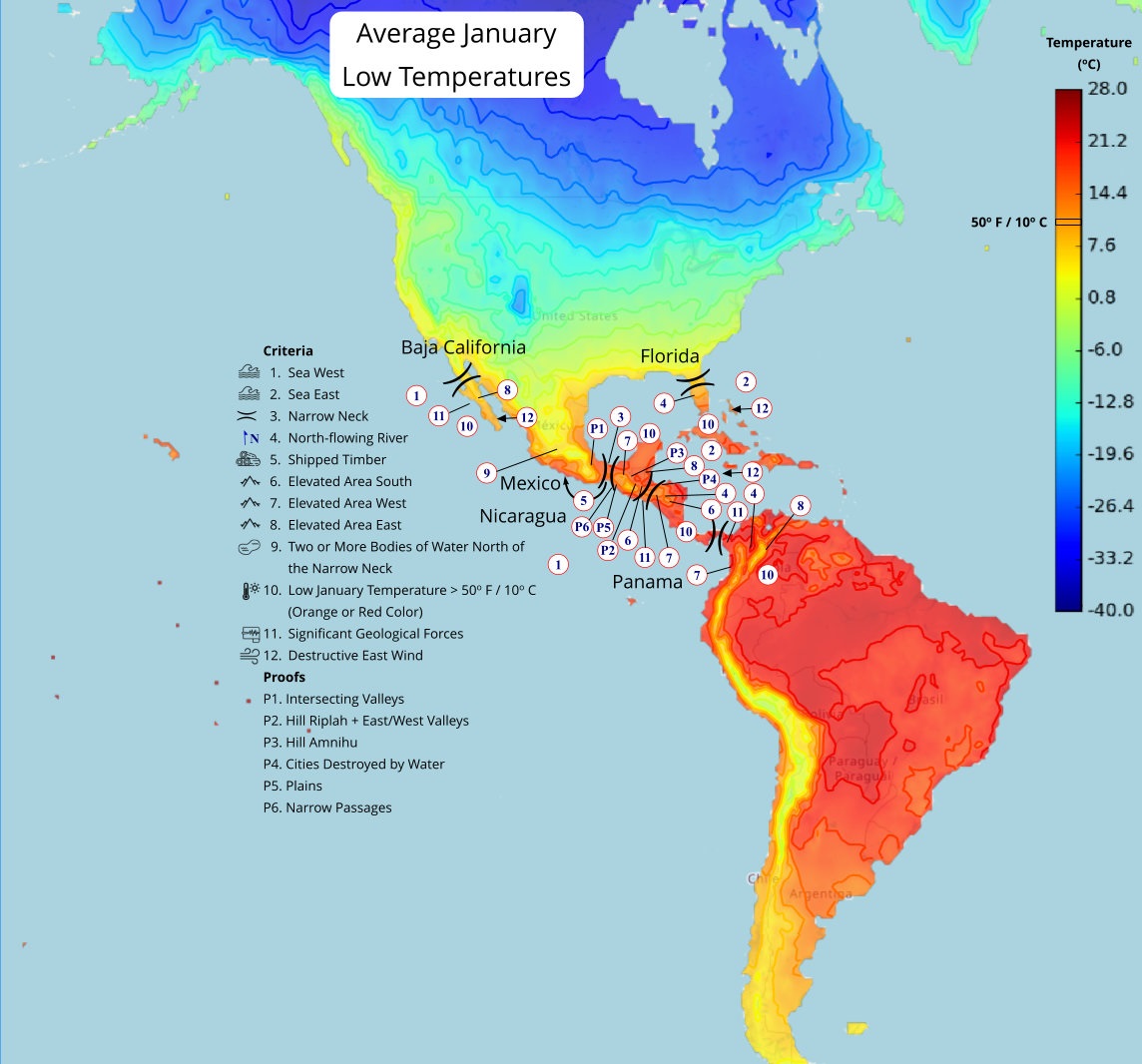



Criteria for the sea East:
- The sea East shore can be sailed to from any shore east or west of Jerusalem
- Water can rise up on the sea East shore near the south wilderness and southward but not on the northward shore north of the south wilderness
- A narrow strip of wilderness south of the narrow neck that runs east/west (the south wilderness) and runs from near the sea East to the sea West
- There is a wilderness (East Wilderness) along the sea East coastline north of the south wilderness
- The coastline of the sea East extends from south of the narrow neck to north of the narrow neck
All possible sea East locations are displayed below. The most likely locations are coasts that can be reached from west of Jerusalem. Starting with the locations nearest to Jerusalem are Egypt, Italy, Denmark, Florida, Mexico, Nicaragua, and Panama.
Denmark

(Tap to Expand)
Egypt

(Tap to Expand)
England

(Tap to Expand)
Florida

(Tap to Expand)
Italy

(Tap to Expand)
Korea

(Tap to Expand)
Malaysia

(Tap to Expand)
Mexico

(Tap to Expand)
Nicaragua

(Tap to Expand)
Panama

(Tap to Expand)
Russia

(Tap to Expand)
×
![]()
