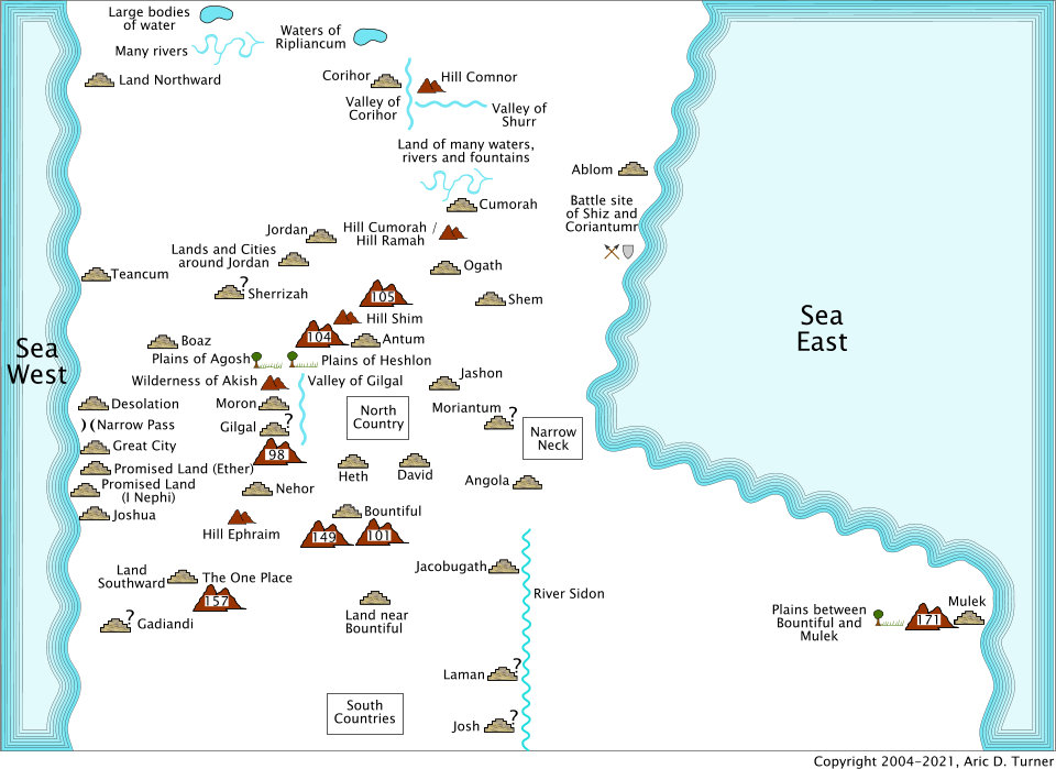
This is the place of Ogath. Places without the designation of a land or city are in other parts of the Book of Mormon referred to eventually as a land. Due to the practice of naming a land by the same name as the city, it is presumed to also be the city of Ogath. Ogath is next to and southward of the hill Ramah/hill Cumorah and southward of the waters of Ripliancum.
Commentaries (
view it on a map)
ETHER 6:82 [15:10]: And it came to pass that the armies of Coriantumr did press upon the armies of Shiz, that they beat them, that they caused them to flee before them; and they did flee southward, and did pitch their tents in a place which was called Ogath.
Commentary: This verse references the places of Ogath, the valley of Cohor, the valley of Shurr, and the waters of Ripliancum. The battle started at the waters of Ripliancum, so, Ogath is south of the waters of Ripliancum. With the armies heading southward, the armies of Shiz were south of the armies of Coriantumr. The armies would have passed again through the Valleys of Cohor and Shurr to get to Ogath.
ETHER 6:83 [15:11]: And it came to pass that the army of Coriantumr did pitch their tents by the hill Ramah; and it was that same hill where my father Mormon did hide up the records unto the Lord which were sacred.
Commentary: This verse references the places of the hill Cumorah, the hill Ramah, and Ogath. The hill Ramah is near Ogath and southward of the waters of Ripliancum. Hill Cumorah is the same hill where the records were hidden. So, the hill Ramah is the hill Cumorah. The phrase 'And it came to pass' indicates time had passed, but there is no indication of how much time had elapsed. Coriantumr was pursuing Shiz southward, so the army of Coriantumr would be northward of the army of Shiz. This puts the hill Ramah north of the land of Ogath. They stayed in these positions for four years gathering all the people (Ether 6:86 [15:14]). These locations needed to be able to sustain large numbers of people for four years.
Map