ALMA 13:69 [22:27]: Which ran from the sea east, even to the sea west, and round about on the borders of the sea-shore, and the borders of the wilderness which was on the north, by the land of Zarahemla, through the borders of Manti, by the head of the river Sidon, running from the east towards the west; and thus were the Lamanites and the Nephites divided.
Part of the land (one side) of Manti was wilderness and part (the other side) was not.ALMA 26:134 [58:13]: And thus we did go forth with all our might against the Lamanites, who were in the city of Manti; and we did pitch our tents by the wilderness side, which was near to the city.
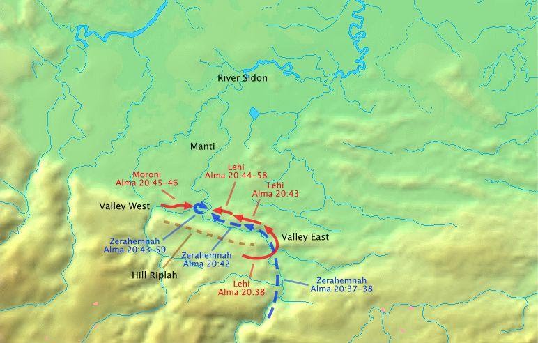
This provides a distinct description where the headwaters of the river Sidon passed through the land of Manti where the wilderness (hilly terrain) transitioned to non-wilderness (flat terrain). Moroni positioned his army near this area in a valley on the west of the river Sidon on the wilderness side of the land of Manti. Valleys contain a stream or river.Alma 20:27 And it came to pass that the word of the Lord came unto Alma, and Alma informed the messenger of Moroni that the armies of the Lamanites were marching round about in the wilderness...
Alma 20:31 And it came to pass, that Moroni caused that his army should be secreted in the valley which was near the bank of the river Sidon, which was on the west of the river Sidon, in the wilderness.
Alma 20:35 Therefore he divided his army, and brought a part over into the valley, and concealed them on the east, and on the south of the hill Riplah; and the remainder he concealed in the west valley, on the west of the river Sidon, and so down into the borders of the land of Manti.
When the Lamanite army came by, they went on the north side of the hill Riplah. On the north side was the river Sidon.Alma 20:37 And it came to pass that the Lamanites came up on the north of the hill where a part of the army of Moroni was concealed.
Alma 20:38 And as the Lamanites had passed the hill Riplah, and come into the [west] valley, and began to cross the river Sidon, the army which was concealed on the south of the hill, which was led by a man whose name was Lehi; and he led his army forth and encircled the Lamanites about, on the east in their rear.
- Where wilderness transitioned to non-wilderness at the point where the river Sidon goes through the land of Manti.
- Where a west and east valley occur close to each other.
- Where the river passes on the north side of a hill that can conceal an army on the south side of the hill.
Battle around Hill Riplah (Internal Model)

There are two north-flowing rivers in Mesoamerica south of a narrow neck, the Usumacinta and Grijalva rivers. The following geography is where the Usumacinta River (the river Sidon) exits the wilderness and into the flat lowlands.
Battle around Hill Riplah (Guatemala)

