
Question: Who named the city in Iowa 'Zarahemla' and when did they name it?
On July 2, 1839, the Prophet Joseph Smith and other Latter-day Saint leaders crossed the Mississippi River to the Territory of Iowa to inspect land purchased by Church agent Vinson Knight from land speculator Isaac Galland. When the Prophet Joseph was about a mile west of Montrose, he advised that 'a town be built there, and called Zarahemla.' (LDS The History of the Church)
From Brigham Young's diary for July 2, 1839: 'Brothers Joseph, Hyrum and others came over the river to Montrose, and went out on the prairie and looked out the sight for a city for the Saints, which was called Zarahemla.'
Elias Smith journal, 16 August 1840 (8 months before LDS D&C 125), referred to a 'conference at Zarahemla.'
1841, LDS D&C 125 (no RLDS source) - Let them build up a city unto my name upon the land opposite the city of Nauvoo, and let the name of Zarahemla be named upon it.
- Note: The place of Zarahemla, Iowa, was not named prophetically in 1839. There is nothing in the original naming or the LDS revelation that indicated the place was the same as Zarahemla in the BoM
A statement used to justify the Heartland Model (Evening and Morning Star - EMS, No. 5, Oct 1832)
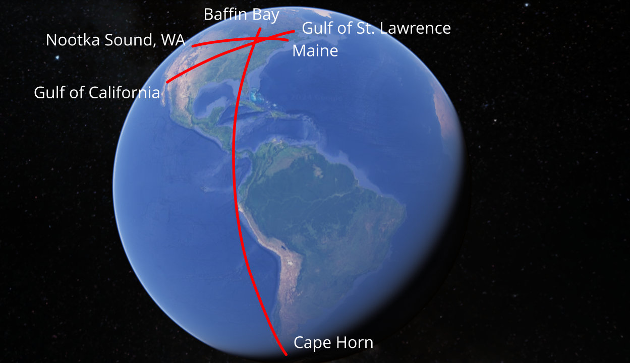
- To return: this beautiful region of country is now mostly, excepting Arkansas and Missouri, the land of Joseph or the Indians, as they are called, and embraces three fine climates: First, like that of New-York; second, like Missouri, neither northern nor southern; and third, like the Carolinas. This place may be called the centre [center] of America; it being about an equal distance from Maine, to Nootka sound; and from the gulf of St. Lawrence to the gulf of California; yea, and about the middle of the continent from cape Horn, south, to the head land at Baffin's Bay, north. The world will never value the land of Desolation, as it is called in the book of Mormon, for any thing more than hunting ground, for want of timber and mill-seats: The Lord to the contrary notwithstanding, declares it to be the land of Zion which is the land of Joseph, ...
Let's read what this passage really says:
The article in The Evening and Morning Star, No. 5, Oct 1832
- To return: this beautiful region of country is now mostly, excepting Arkansas and Missouri, the land of Joseph or the Indians, as they are called, and embraces three fine climates: First, like that of New-York; second, like Missouri, neither northern nor southern; and third, like the Carolinas. This place may be called the centre [center] of America; it being about an equal distance from Maine, to Nootka sound; and from the gulf of St. Lawrence to the gulf of California; yea, and about the middle of the continent from cape Horn, south, to the head land at Baffin's Bay, north. The world will never value the land of Desolation, as it is called in the book of Mormon, for any thing more than hunting ground, for want of timber and mill-seats: The Lord to the contrary notwithstanding, declares it to be the land of Zion which is the land of Joseph, ...
Hemispheric Geography Model (1832)
(Tap to Expand)
The article in The Evening and Morning Star, No. 5, Oct 1832
- Was talking about the North America and South America (Hemispheric) Model
- This was the common Book of Mormon geography view of that time
- NOT a Heartland Model
- Orson Pratt was the best-known proponent of the Hemispheric Model - Started preaching it in early 1832 - explains the reference in The EMS, Oct 1832
Joseph Smith, himself as Editor, stated that the Zarahemla of the Book of Mormon was in Mesoamerica (Times and Seasons, Oct 1, 1842, Vol 3, Number 23)
- It is certainly a good thing for the excellency and veracity, of the divine authenticity of the Book of Mormon, that the ruins of Zarahemla have been found where the Nephites left them: and that a large stone with engravings upon it as Mosiah said; and a 'large round stone, with the sides sculptured in hieroglyphics,' as Mr. Stephens has published, is also among the left remembrances of the, (to him,) lost and unknown. We are not going to declare positively that the ruins of Quirigua [Quer-ee-gua] are those of Zarahemla, but when the land and the stones, and the books tell the story so plain, we are of opinion, that it would require more proof than the Jews could bring to prove the disciples stole the body of Jesus from the tomb, to prove that the ruins of the city in question, are not one of those referred to in the Book of Mormon.
×
![]()