
What is the History behind the hill Cumorah?
So, let's talk about hill Cumorah in New York - just to make sure we're clear what it represents
Question #1: Who named the hill in the grove "hill Cumorah"?
- First reference is Jan, 1833, The Evening and Morning Star, Vol1, No. 8
- Article written by W.W. Phelps in Independence, MO
- Note: Joseph Smith was in Kirtland, NY at this time
The Evening and Morning Star, Vol1, No. 8
- "This was welcome news to them that looked for the gathering of the righteous, in the last days. They, from a perusal of this book, aided by the Spirit of God, began to see eye to eye in some things, and to lift up their heads and rejoice.-But before the glorious and happy results of this book are set forth, it seems necessary to go back to the time it was brought forth. In the year one thousand eight hundred and twenty seven, the plates came forth from the hill Cumorah, which is in the county of Ontario, and state of New-York, by the power of God. In less than three years after, it was translated by the gift and power of God, and then published; and on the 6th of April, 1830, the church of Christ was organized, with six members."
Let's focus on the naming ...
- "In the year one thousand eight hundred and twenty seven, the plates came forth from the hill Cumorah, which is in the county of Ontario, and state of New-York,..."
- There's a Problem - the plates of Moroni (that Joseph Smith found) were not the same plates that were hid-up in the hill Cumorah in the Book of Mormon.
- The plates of Mormon are still there in the hill Cumorah.
Let's focus on who named the hill "Cumorah."
- Joseph Smith did not communicate with W.W. Phelps in 1832 any letter that mentioned "hill Cumorah."
- Joseph Smith Jr sent 5 letters from Kirtland to Independence in 1832 - they all contained doctrine and no descriptions from the Book of Mormon.
- No newspapers in Palmyra or Kirtland or other cities round about in 1829 1830, or 1831 mention "hill Cumorah."
- There were about 30 articles published including some in-depth "spoofs."
- The articles always mention the "hill" or the "grove" regarding where Joseph Smith found the plates.
- None of the early descriptions by Joseph Smith of his vision / encounters with angels or digging up the plates mention "hill Cumorah" (1832, 1835- mentions "the grove", 1839).
- So, the hill was not "prophetically named" as the hill in the Book of Mormon.
- Joseph Smith did not mention "hill Cumorah" in his personal journal from 1834 through 1844.
- The real person who named the hill - "hill Cumorah" ...
- On Feb 8, 1832, Lyman E. Johnson and Orson Pratt visited B. Stokely.
- Stokely recorded their conversation and submitted a letter to The Western Press, Mercer, Pennsylvania - Orson Pratt said:
- "Six hundred years before Christ a certain Prophet called Lehi went out to declare and promulgate the prophecies to come; he came across the water into South America,...The last battle that was fought among these parties was on the very ground where the plates were found; but it had been a running battle, for they commenced at the Isthmus of Darien and ended at Manchester."
- Orson Pratt began promulgating the Hemispheric Geography Theory (North and South America) in at least early 1832.
- There are comments made by Parley Pratt in 1831 that could be inferred that he knew about the Hemispheric Geography Theory.
- It appears that W.W. Phelps named the hill based on Orson Pratt's geography studies and the Hemispheric Model.
- Parley Pratt and W.W. Phelps were both in attendance at the Conference held in Independence in January 1832.
- Note: Orson Pratt was at the Conference in Amherst OH in January 1832 and then left to do missionary work for most of 1832 - which is when he encountered B. Stokely. No communication between Orson Pratt with W.W. Phelps in 1832 can be found.
- After the article in the Evening and Morning Star, people started to call it "hill Cumorah" and the name stuck.
Question #2: Does the hill in New York match the Book of Mormon geography for hill Cumorah?
- What do we know about the hill Cumorah from the Book of Mormon?
- Hill Shim: The hill Shim is in the land of Antum (which is next to the land of Jashon). The hill Shim is eastward of the city of Boaz, northward of the narrow neck, southward of the hill Ramah/hill Cumorah, and westward of Ablom. The hill Shim is several days' travel from the lands of Nehor and Heth (near the place of the Jaredites first landing near the narrow neck).
- ETHER 4:3 [9:3] states that Omer and his family "traveled many days" (more than one day) from Nehor (in the narrow neck area) to reach the hill Shim.
- Hill Cumorah: The hill Cumorah is in the land of Cumorah. The hill Cumorah is the same as the hill Ramah. The hill Cumorah is southward of the waters of Ripliancum, northward of Ogath, northward of the hill Shim, westward of Ablom, and eastward of the land of Jordan.
- Between Mormon 2:25 [4:23] where Mormon retrieves the plates from the hill Shim and the last battle at the hill Cumorah, these events take place:
- The Nephites fled from the city of Boaz (south of the hill Shim) to the city of Jordan where the Lamanites were stopped for a time Mormon 2:28 [5:3]
- There were several more lands north of the narrow neck between Boaz and the city of Jordan - "that whatsoever lands we had passed by, and the inhabitants thereof were not gathered in, were destroyed by the Lamanites, and their towns, and villages, and cities were burned with fire;" Mormon 2:31 [5:5]
- The Nephites had to "again take to flight" Mormon 2:33 [5:7]
- The Nephites took four years to gather in the remaining Nephites to the hill Cumorah from Mormon 2:32 [5:6] (380th year) to Mormon 3:6 [6:5] (384th year)
- Note: There was some distance between the hill Shim and hill Cumorah to have distance to "take flight."
- The Book of Mormon is clear that hill Cumorah is north of the narrow neck.
- Where is there a "narrow neck" (bordering a sea West / ocean) and south of hill Cumorah in NY in the Heartland Theory? There is no place.
- The "narrow neck" south of hill Cumorah in NY is the Isthmus of Darien (Panama in the Hemispheric Model as described by Orson Pratt).
Heartland Model Assessment:
Here is a summary of the relative positions of the land Desolation to other places:
- The land Desolation was northward of the Land Bountiful and the narrow pass. The land Desolation was southward of the land of Teancum, land of Boaz, and land northward. The land Desolation is next to the Sea West. The city Desolation was on the shores of the Sea West. The land Desolation was in proximity to Lehi's first landing in the Promised Land (I Nephi). The land Desolation is near the land of Moron.
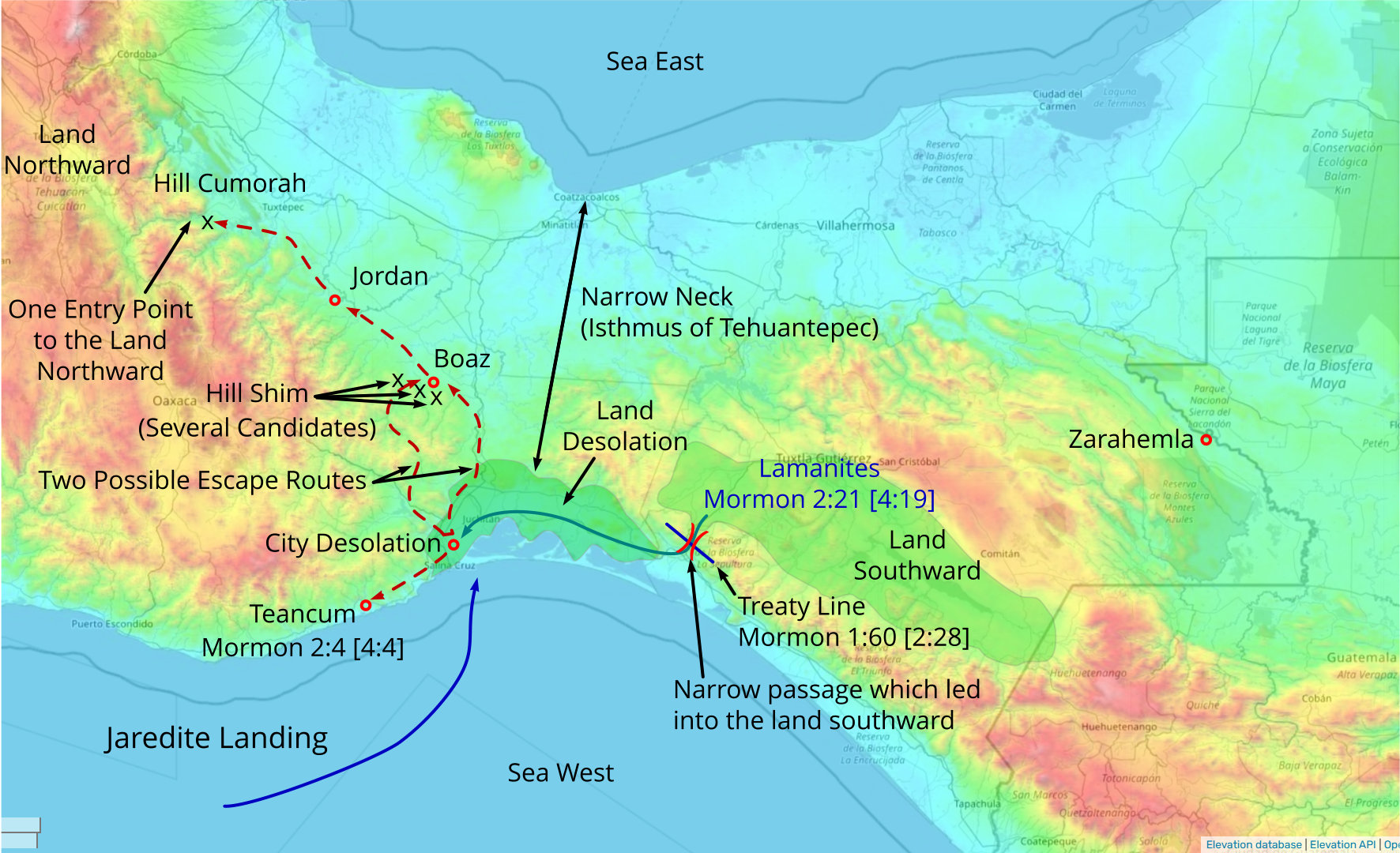
Based on the Heartland Model (Source), the image of the Final Battles shows the movements of the Lamanites and Nephites in the final battles leading up to the Nephites assembling around the hill cumorah.
MORMON 1:60 [2:28] And in the three hundred and fiftieth year, we made a treaty with the Lamanites and the robbers of Gadianton, in which we did get the lands of our inheritance divided.
MORMON 1:61 And the Lamanites did give unto us the land northward; yea, even to the narrow passage which led into the land southward.
MORMON 2:4 [4:4] Now the city Teancum lay in the borders by the seashore; and it was also near the city Desolation.
MORMON 2:21 [4:19] And it came to pass that the Lamanites did come down against the city Desolation; and there was an exceeding sore battle fought in the land Desolation, in the which they did beat the Nephites.
MORMON 2:25 [4:23] And now I, Mormon, seeing that the Lamanites were about to overthrow the land, therefore I did go to the hill Shim, and did take up all the records which Ammoron had hid up unto the Lord.
MORMON 2:28 [5:3] And it came to pass that the Lamanites did come against us as we had fled to the city of Jordan; but behold, they were driven back that they did not take the city at that time.
MORMON 2:31 [5:5] But it came to pass that whatsoever lands we had passed by, and the inhabitants thereof were not gathered in, were destroyed by the Lamanites, and their towns, and villages, and cities were burned with fire; and thus the three hundred and seventy and nine years passed away.
MORMON 2:33 [5:7] And it came to pass that we did again take to flight, and those whose flight was swifter than the Lamanites did escape, and those whose flight did not exceed the Lamanites were swept down and destroyed.
MORMON 3:3 [6:2] And I, Mormon, wrote an epistle unto the king of the Lamanites, and desired of him that he would grant unto us that we might gather together our people unto the land of Cumorah, by a hill which was called Cumorah, and there we would give them battle.
Note: The Heartland Model does not specify locations for Teancum, Boaz, or Jordan. But, given that the Book of Mormon specifies that Teancum is on a sea shore close to the city of Desolation, the only location that fits that description is the north shore of Lake Erie. Boaz and Jordan have to be between the city of Desolation and hill Cumorah and northward (away from the attacking Lamanites), meaning they would be located on the south shore area of Lake Ontario.
Final Battles (Heartland Model)
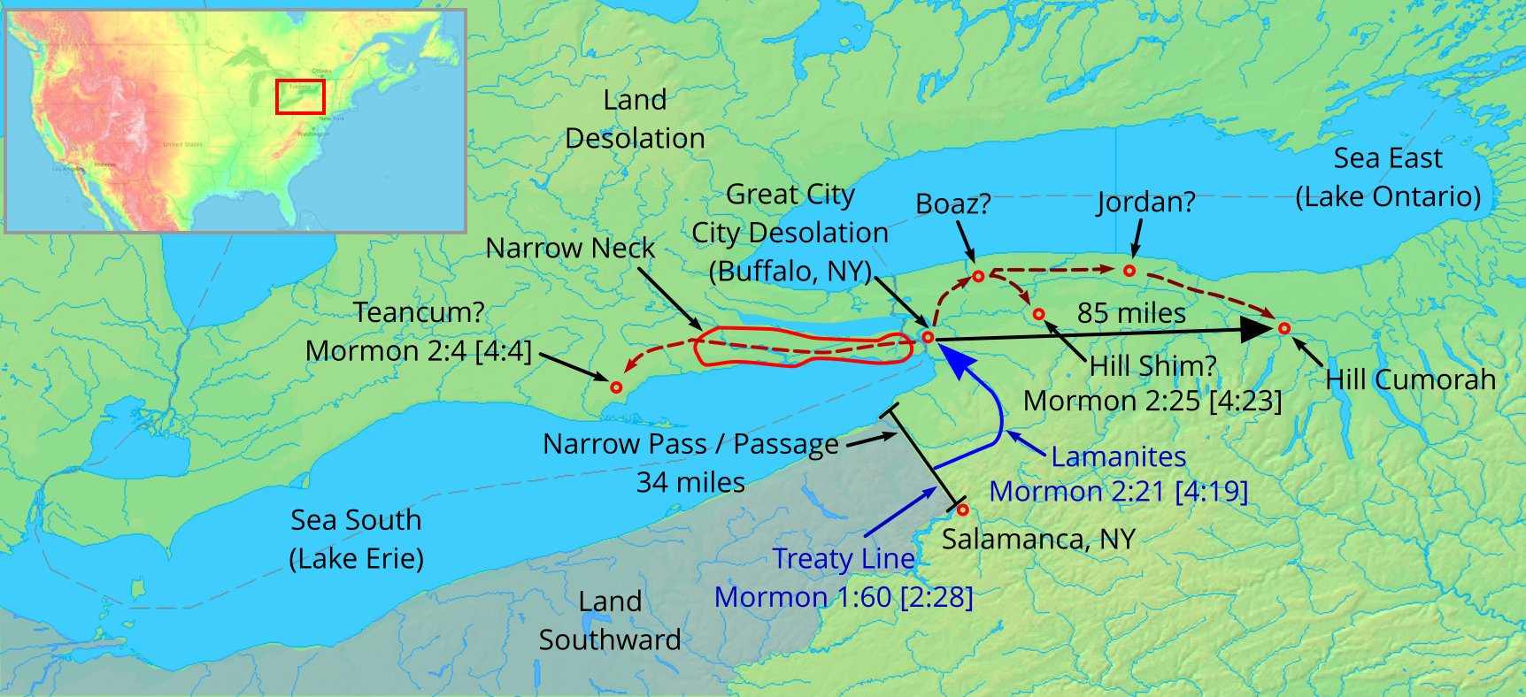
(Tap to Expand)
While the Nephites were in the city of Boaz, Mormon went to the hill Shim to retrieve the plates. The area of the Lake Ontario shore where Boaz would have to be located is a gently sloped region with no hills.
Boaz and Hill Shim (Heartland Model)
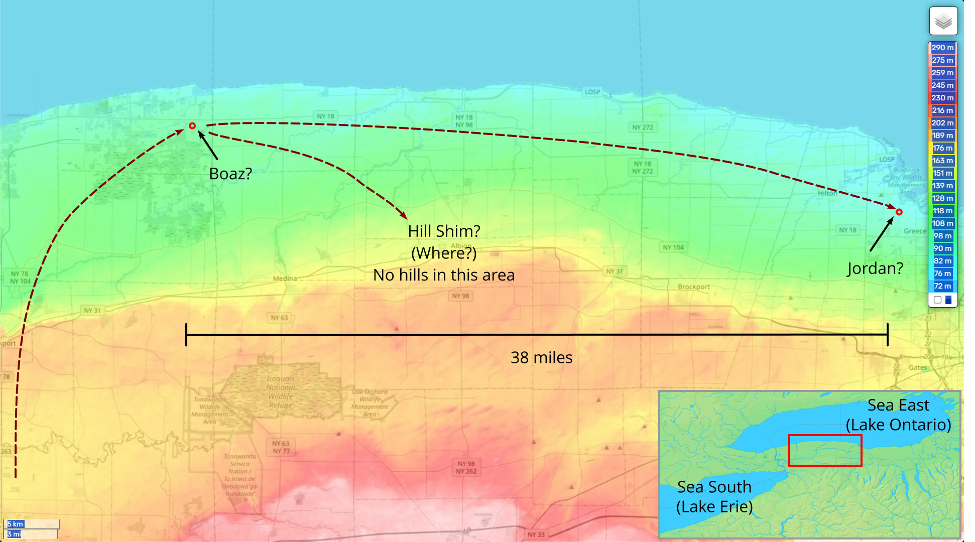
(Tap to Expand)
After being driven from the city of Jordan, the Nephites assembled at hill Cumorah. In New York, there are several hills similar to the hill Cumorah that are near hill Cumorah. There is also a much larger Baker Hill (summit: 927 feet) that is 11 miles from hill Cumorah and a better strategic location. The Heartland model does not provide any rationale why the hill Cumorah was selected over any other hill in the area.
Hill Cumorah (Heartland Model)
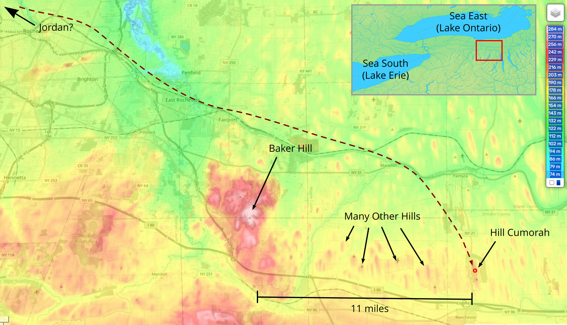
(Tap to Expand)
The Book of Mormon states that the hill Cumorah was north of (away from the Lamanites to the south), or at least within the borders of the land Desolation. The name for the land Desolation was due to the destruction of the Jaredites. The Jaredites built on the land where they first landed (1 Nephi 5:212-213). The Heartland land Desolation is land-locked - there is no place for the Jaredites to land on a shore of their Promised Land. This land of Desolation was near where Lehi's group first landed in the new world. As can be seen in the image below, the Heartland location for the land desolation is nowhere near the location of the Nephites first landing (Alma 13:74).
I NEPHI 5:212 [18:23]: And it came to pass that after we had sailed for the space of many days, we did arrive to the promised land;
I NEPHI 5:213 [18:23]: And we went forth upon the land, and did pitch our tents; and we did call it the promised land.
MOSIAH 5:63 [8:8] Having discovered a land which had been peopled with a people who were as numerous as the hosts of Israel.
MOSIAH 9:167 [21:26] Nevertheless they did find a land which had been peopled; yea, a land which was covered with dry bones; yea, a land which had been peopled, and which had been destroyed;
ALMA 13:74 [22:30] And it bordered upon the land which they called Desolation; it being so far northward, that it came into the land which had been peopled, and been destroyed, of whose bones we have spoken, which was discovered by the people of Zarahemla; it being the place of their first landing. And they came from there up into the south wilderness.
Land Desolation (Heartland Model)
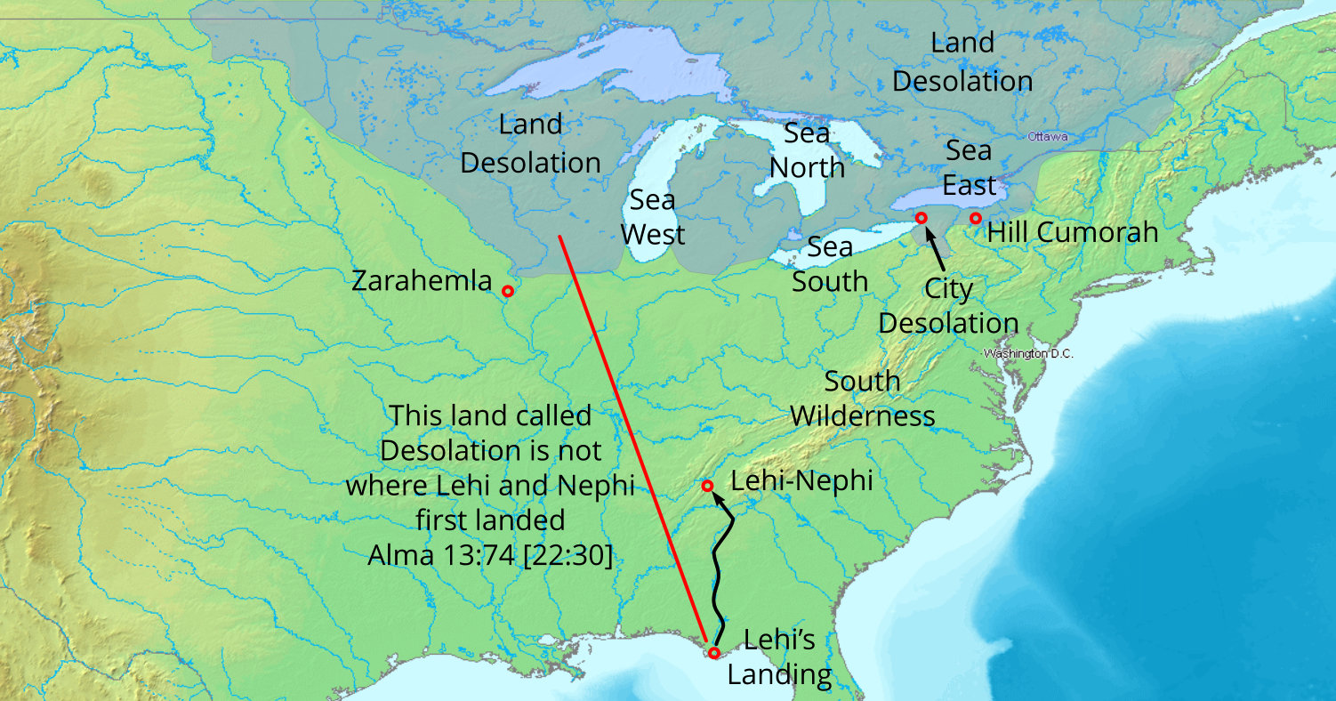
(Tap to Expand)
Isthmus of Tehuantepec (Mexico) Model Assessment:
The image of the Final Battles in the Isthmus of Tehuantepec area shows the same information as the Heartland Model. The key differences:
- The west coast is a natural landing point for the Jaredites (see Sea West) making this spot their Promised Land / Land of their inheritance and the land they populated the most.
- There is only one pass / passage from the highlands of the upper Grijalva River basin (land Southward) to the coast - making this a very strategic spot to be able to defend and keep the Lamanites from coming down from the land Southward (Mormon 1:60-61 [2:28-29]).
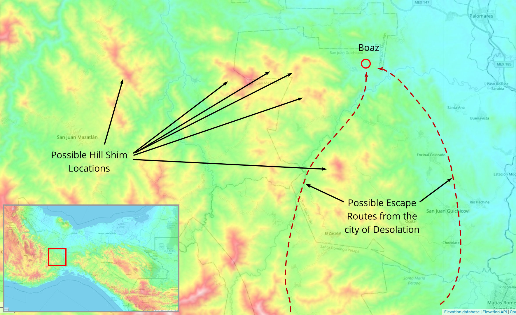
- There is a place about 70 miles (several days) from the city of Desolation where there are several hills that can be candidates for the hill Shim (Mormon 2:25 [4:23])
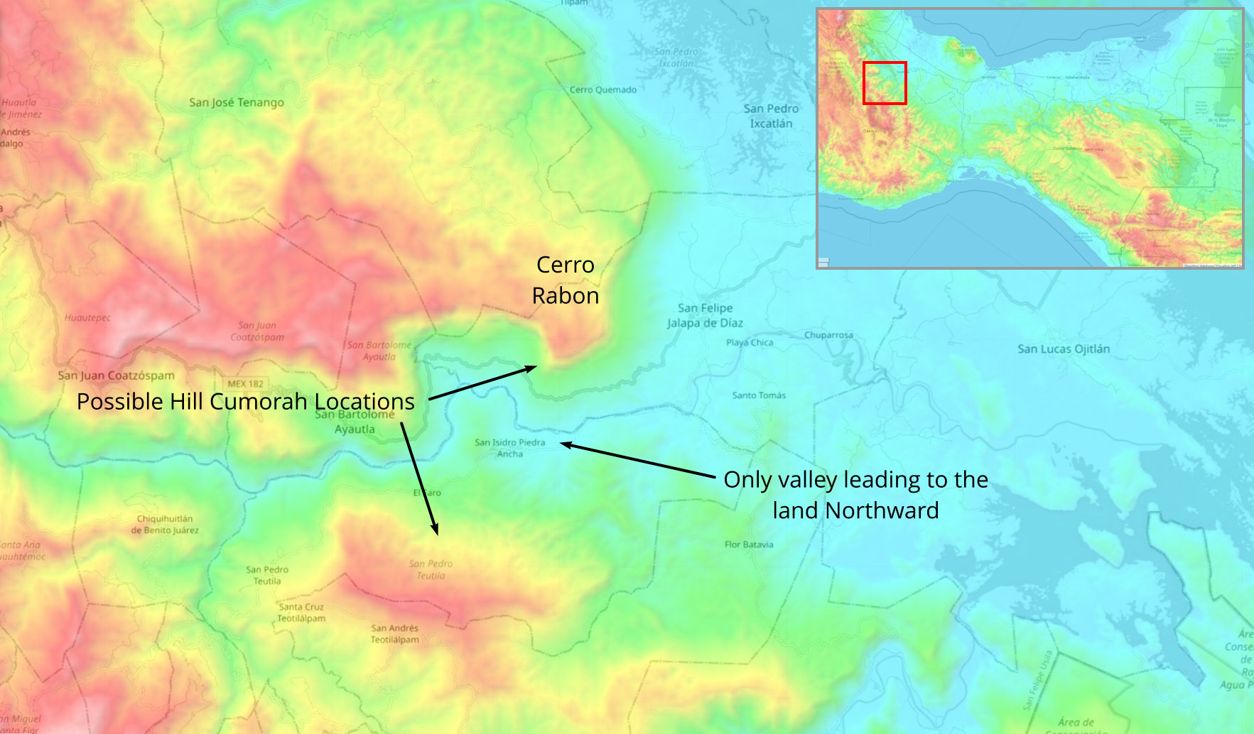
- The area for the hill Cumorah (about 130 miles from Boaz) is a very strategic location at the mouth of the only valley leading to the land Northward - making this the reason for assembling at the hill Cumorah - to prevent the Lamanites from getting into the land Northward where the remaining Nephite lands were located.
Final Battles (Isthmus of Tehuantepec)
(Tap to Expand)
As the Nephites were driven out of the city Desolation, they were driven further and further north. The area just outside the narrow neck has several hills that are possible locations for the hill Shim.
Hill Shim Possible Locations (Isthmus of Tehuantepec)
(Tap to Expand)
Eventually, after being driven out of the city Jordan, the last place to make a stand against the Lamanites before having to retreat into the land Northward is at the mouth of the one valley that is the entrance to the land Northward. There is no strategic location in the land Northward that is defensible to prevent the Lamanites from spreading throughout the land Northward.
Hill Cumorah Possible Locations (Isthmus of Tehuantepec)
(Tap to Expand)
The Promised Lands of the Book of Mormon match the Isthmus of Tehuantepec location:
ETHER 3:13 [6:11]: And thus they were driven forth, three hundred and forty and four days upon the water; and they did land upon the shore of the promised land.
- Commentary: The Promised Land of the Jaredites begins at a seashore.
I NEPHI 5:212 [18:23]: And it came to pass that after we had sailed for the space of many days, we did arrive to the promised land;
I NEPHI 5:213 [18:23]: And we went forth upon the land, and did pitch our tents; and we did call it the promised land.
- Commentary: The Promised Land of Lehi begins at a seashore.
ALMA 13:71 [22:28]: Yea, and also on the west of the land of Zarahemla, in the borders, by the sea-shore, and on the west, in the land of Nephi, in the place of their fathers' first inheritance, and thus bordering along by the sea-shore.
- Commentary: This verse references the places of Nephi, the Promised Land (I Nephi), the Sea West, and Zarahemla. This verse is describing the locations of idle Lamanites. The borders by the seashore were west of Zarahemla and on or near the sea (Sea West). They were also in the west parts of the land of Nephi all the way to the Sea West shore. The place of their father's first inheritance, the Promised Land (I Nephi), is located on the Sea West shore.
ALMA 13:74 [22:30]: And it bordered upon the land which they called Desolation; it being so far northward, that it came into the land which had been peopled, and been destroyed, of whose bones we have spoken, which was discovered by the people of Zarahemla; it being the place of their first landing. And they came from there up into the south wilderness.
- Commentary: Refers to the land where the Nephites first landed on the shore as being where the Jaredites were destroyed.
Land Desolation (Isthmus of Tehuantepec)
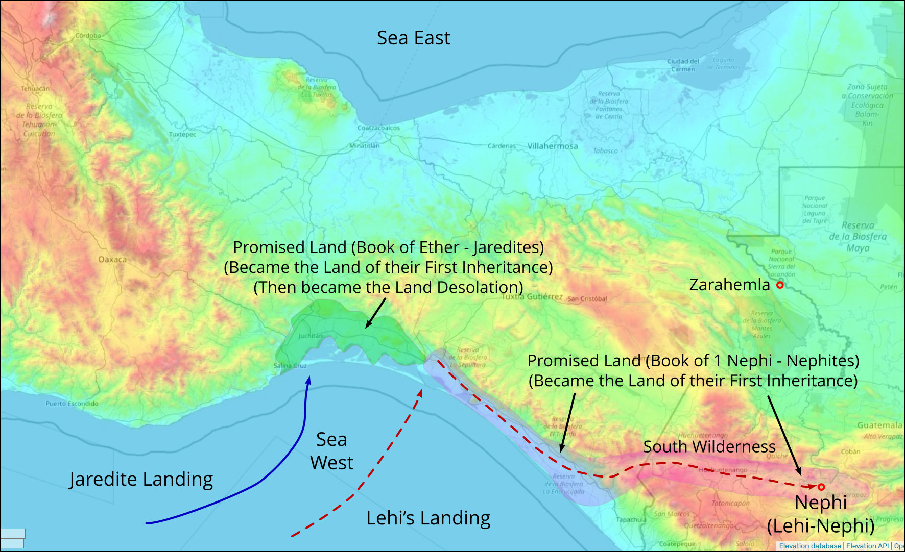
(Tap to Expand)
SUMMARY:
- Joseph Smith, Jr. never referred to the hill where he found the plates as "hill Cumorah" in his written testimonies of his vision and meeting with angels regarding being directed to the plates
- He referred to the hill as "the grove" in his 1835 testimony.
- Orson Pratt described, in 1832, the hill where Joseph Smith, Jr. found the plates of the Book of Mormon (plates of Moroni) as the hill Cumorah from the Book of Mormon.
- W.W. Phelps printed the name of the hill as "hill Cumorah" in the Evening and Morning Star, January 1833, from Orson Pratt's description, as related by Parley Pratt.
- The hill Cumorah was not named prophetically - it was named due to Orson Pratt's Hemispheric Geography Model.
- Doctrine and Covenants Section 110 [LDS Section 128], given to Joseph Smith Jr, in 1842 (9 years after hill Cumorah was named by Orson Pratt and W.W. Phelps) refers to the land around hill Cumorah ("Glad tidings from Cumorah!") only as a reference because the hill had already been named nine years prior.
- The New York location for the hill Cumorah does not match the Book of Mormon geography descriptions (Alma 13:74)
- There are several aspects of the Heartland geography that do not match the Book of Mormon descriptions:
- Lehi's landing on the Gulf shore is not where the Jaredites were destroyed (land Desolation in Canada).
- The land Desolation being in Canada does not allow the Jaredites to land on a sea shore that is their Land of Promise.
- There is no hill in the area where the hill Shim should be (near the south shore of Lake Ontario).
×
![]()