
Distances mentioned in the Book of Mormon
The plains of Nephihah are mentioned in one verse in the Book of Mormon:
ALMA 29:21 [62:18]: And it came to pass that when they [Moroni and his army from Zarahemla] had come to the city Nephihah, they did pitch their tents in the plains of Nephihah, which is near the city Nephihah.
- Commentary: In Hebrew, the phrase "is near" [<qarowb> H7138] is used for "next to" or "adjacent." So, the plains of Nephihah are adjacent to the city of Nephihah.
ALMA 29:26 [62:22] And it came to pass that Moroni caused that his men should march forth and come upon the top of the wall, and let themselves down into that part of the city, yea, even on the west, where the Lamanites did not camp with their armies.
ALMA 29:27 [62:23] And it came to pass that they were all let down into the city by night, by the means of their strong cords and their ladders; thus when the morning came, they were all within the walls of the city.
ALMA 29:28 [62:24] And now when the Lamanites awoke, and saw that the armies of Moroni were within the walls, they were affrighted exceedingly, insomuch that they did flee out by the pass.
ALMA 29:29 [62:25] And now when Moroni saw that they were fleeing before him, he did cause that his men should march forth against them, and slew many, and surrounded many others and took them prisoners; and the remainder of them fled into the land of Moroni, which was in the borders of the sea-shore.
Isthmus of Tehuantepec (Mexico) Model Assessment:
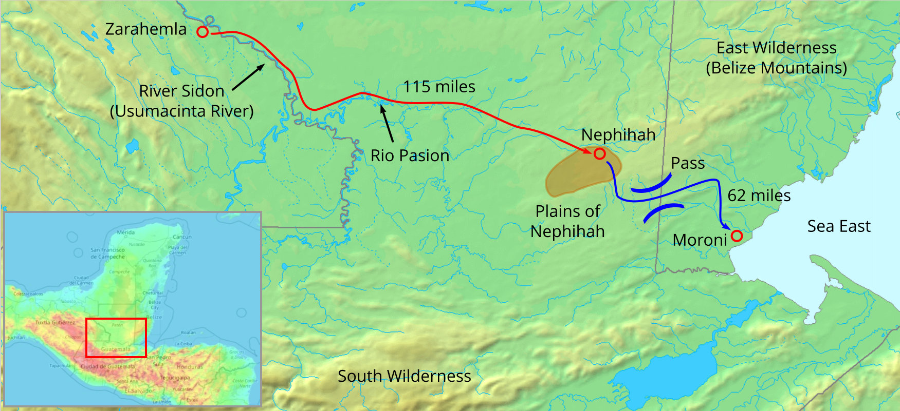
The city of Nephihah is close to the sea East but not on the coast. It is near a pass that can be used to get to the coast. The Belize Mountains creates a rain shield for the west side of the mountains. The area around Poptun, Guatemala occurs an area of drier climate that contains the only prairie vegetation in Central America. This proximity to the only pass through the Belize mountains makes this area the likely location for the plains of Nephihah. The city of Nephihah is located on the plains of Nephihah.
The Isthmus of Tehuantepec location maintains all of the descriptions in the Book of Mormon and maintains logical army movements for both the Nephites and Lamanites.
Plains of Nephihah (Isthmus of Tehuantepec)
(Tap to Expand)
Heartland Model Assessment:
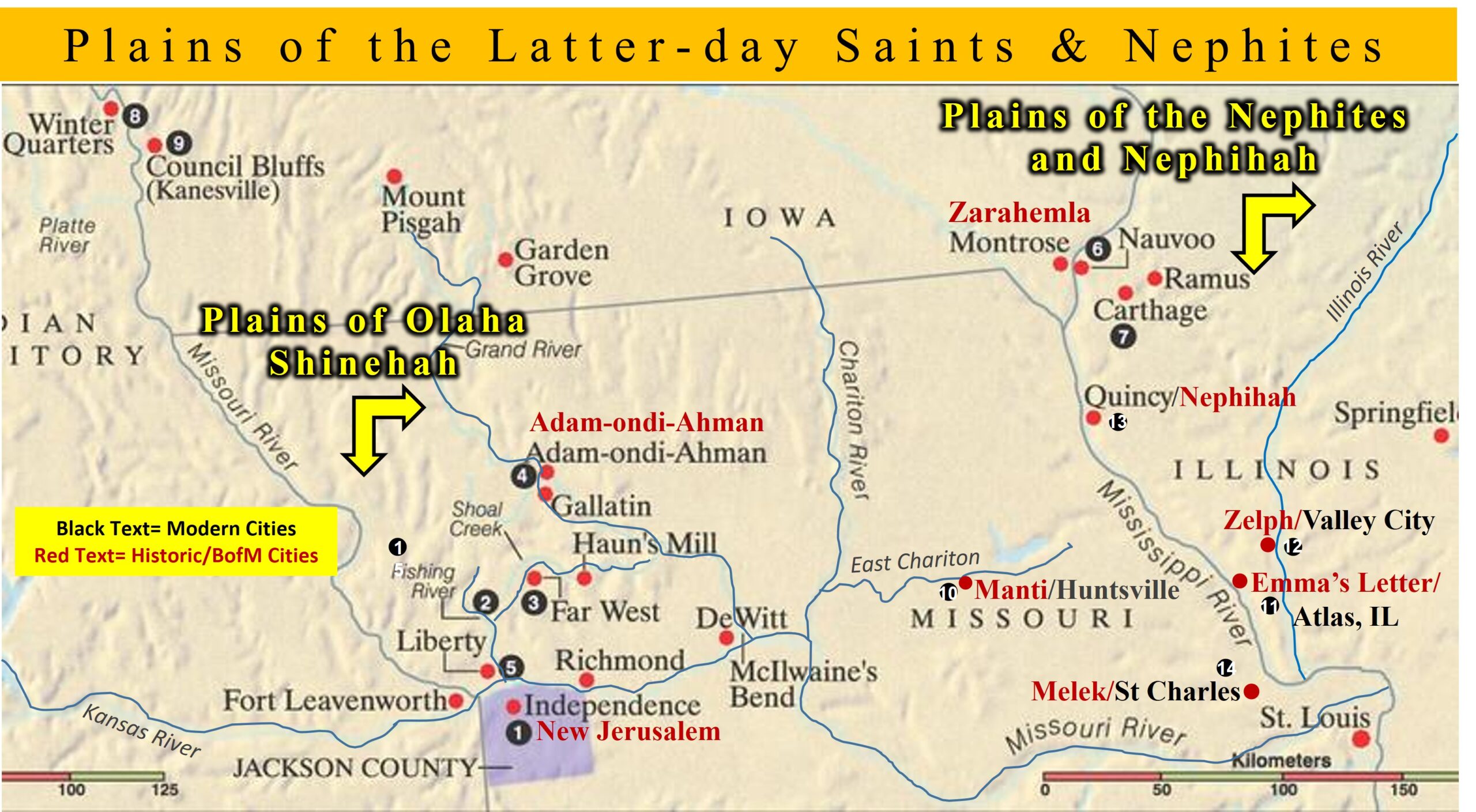
The Heartland Model places:
- The city of Nephihah at Quincy, Illinois (53 miles south of Montrose, Iowa - Zarahemla) [source: bookofmormonevidence.org - click to view the map].
- The plains of Nephihah in Indiana [same source - click to view the map].
- The city of Moroni near the current Wilmington, Delaware [source: bookofmormonevidence.org - click to view the map].
- Note: This map has another city of Nephihah located near Scranton, Pennsylvania.
- The Heartland Model does not specify a pass, but the primary pass between Quincy, IL, and Wilmington, DE, is the Cumberland Gap. In the 1700's, there was a road called the "Great Valley Road" that was used to travel the same route as described by the Heartland Model places from the Cumberland Gap to the area around Wilmington, DE The Great Valley Road is only mentioned to provide support that this route was the easiest route between those two places.
- The only pass between Scranton, PA and Wilmington, DE is to travel down the Susquehanna River.
The distance between Zarahemla (Montrose, IA) and the nearest part of Indiana is 230 miles. There is no justification that this distance constitutes being "near the city Nephihah." According to Alma 29:26 [62:22], the army of Moroni camped in the plains of Nephihah and then the next night stormed the city of Nephihah. This would require the army of Moroni to travel 230 miles from Indiana to Quincy, IL in less than one day. The current world record for distance running in one day on a flat track is 199 miles. It is not possible to travel 230 miles over uneven ground in less than a day on foot. The Heartland Model also does not explain why an army would travel 460 miles to get to a place that was only 53 miles from their original starting point.
- The Heartland Model locations of the plains of Nephihah and the city of Nephihah (Quincy, IL) does not fit the descriptions in the Book of Mormon.
The distance between the plains of Nephihah (Indiana) and the city of Nephihah #2 (Scranton, PA) is about 600 miles. This is even more impossible to travel in less than one day than traveling to the Nephihah at Quincy, IL.
- Again, the Heartland Model locations of the plains of Nephihah and the city of Nephihah #2 (Scranton, PA) does not fit the descriptions in the Book of Mormon.
Applying Alma 29:29 [62:25] to the Heartland Model locations would mean that the defeated Lamanites traveled 1,290 miles across the Eastern United States. Traveling at 40 miles per day, it takes 32 days to travel that distance. The Heartland Model does not explain why the Lamanites could not find a safe haven between Quincy, IL and Wilmington, DE.
Plains of Nephihah (Heartland Model)
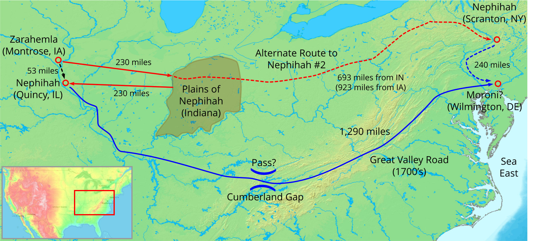
(Tap to Expand)
×
![]()